Rogno geodata
Rogno (Lombardy) is a seat of a third-order administrative division; located in Italy in Europe/Rome (GMT+2) time zone. With population of 3,333 people, there are 2816 cities with bigger population in this country. Compared to other cities in Italy, 87.8% of cities are located further ↓South; 66.5% of cities are located further →East and 52.7% of cities have higher elevation than Rogno. Note1


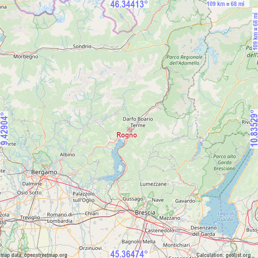
Rogno GPS coordinates[2]
45° 51' 23.724" North, 10° 7' 55.776" East
| Map corner | latitude | longitude |
|---|---|---|
| Upper-left | 46.34413°, | 9.42904° |
| Center: | 45.85659°, | 10.13216° |
| Lower-right: | 45.36474°, | 10.83529° |
| Map W x H: | 108.9×108.9 km | = 67.7×67.7mi |
| max Lat: | 47.04031° ⇑12.2% North |
| Rogno: | 45.85659° |
| min Lat: | ⇓87.8% South 35.50142° |
| min Long | Rogno | max Long |
| 6.69888° | 10.13216° | 18.48682° |
| W 33.5%⇐ | ⇒66.5% E |
Elevation
Elevation of Rogno is 218 m = 715 ft, and this is 88.7 m = 291 ft below average elevation for this country.
| Max E: |
2085 m = 6841 ft | 52.7% |
| Avg. | 306.7 m = 1006 ft | |
| Rogno | 218 m = 715 ft | |
Min E: |
-4 m = -13 ft | 47.3% |
See also: Italy elevation on elevation.city.
Geographical zone
Rogno is located in North temperate zone (between Tropic of Cancer and the Arctic Circle). Distance of this North polar circle is 2302.4 km =1430.6 mi to North.| Distance of | km | miles | from Rogno |
|---|---|---|---|
| North Pole | 4908.3 | 3049.9 | to North |
| Arctic Circle | 2302.4 | 1430.6 | to North |
| Tropic Cancer | 2492.9 | 1549 | to South |
| Equator | 5098.8 | 3168.2 | to South |


Nearby cities:
15 places around Rogno: (largest is in red/bold)
• Angolo Terme
4.1 km =2.5 mi,  19°
19°
• Artogne
2.7 km =1.7 mi,  95°
95°
• Bossico
7.4 km =4.6 mi,  245°
245°
• Castione della Presolana
8.8 km =5.5 mi,  317°
317°
• Castro
7.8 km =4.8 mi,  221°
221°
• Costa Volpino
4 km =2.5 mi, 217°
• Darfo
4.5 km =2.8 mi,  57°
57°
• Darfo Boario Terme
5.9 km =3.7 mi,  48°
48°
• Gianico
3.5 km =2.2 mi,  73°
73°
• Gratacasolo
3.1 km =1.9 mi,  184°
184°
• Lovere
6.8 km =4.2 mi,  225°
225°
• Pian Camuno
1.8 km =1.1 mi,  155°
155°
• Pianico
8.6 km =5.3 mi, 233°
• Pisogne
5.7 km =3.5 mi,  197°
197°
• Sacca
8.3 km =5.2 mi, 54°
Sources, notices
• [Note1] Compared only with cities in Italy existing in our database
• [Src1] Map data: © OpenStreetMap contributors (CC-BY-SA)
• [Src2] Other city data from geonames.org with taken over terms of usage.
• [Src3] Geographical zone / Annual Mean Temperature by Robert A. Rohde @ Wikipedia
