Liveri geodata
Liveri (Campania) is a seat of a third-order administrative division; located in Italy in Europe/Rome (GMT+2) time zone. With population of 1,679 people, there are 4712 cities with bigger population in this country. Compared to other cities in Italy, 79.9% of cities are located further ↑North; 83.3% of cities are located further ←West and 73.3% of cities have higher elevation than Liveri. Note1


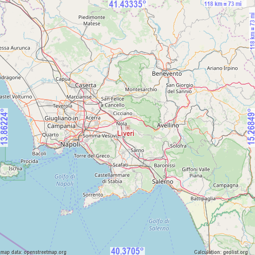
Liveri GPS coordinates[2]
40° 54' 14.616" North, 14° 33' 55.296" East
| Map corner | latitude | longitude |
|---|---|---|
| Upper-left | 41.43335°, | 13.86224° |
| Center: | 40.90406°, | 14.56536° |
| Lower-right: | 40.3705°, | 15.26849° |
| Map W x H: | 118.2×118.2 km | = 73.4×73.4mi |
| max Lat: | 47.04031° ⇑79.9% North |
| Liveri: | 40.90406° |
| min Lat: | ⇓20.1% South 35.50142° |
| min Long | Liveri | max Long |
| 6.69888° | 14.56536° | 18.48682° |
| W 83.3%⇐ | ⇒16.7% E |
Elevation
Elevation of Liveri is 82 m = 269 ft, and this is 224.7 m = 737 ft below average elevation for this country.
| Max E: |
2085 m = 6841 ft | 73.3% |
| Avg. | 306.7 m = 1006 ft | |
| Liveri | 82 m = 269 ft | |
Min E: |
-4 m = -13 ft | 26.7% |
See also: Italy elevation on elevation.city.
Geographical zone
Liveri is located in North temperate zone (between Tropic of Cancer and the Arctic Circle). Distance of this Northern Tropic circle is 1942.2 km =1206.8 mi to South.| Distance of | km | miles | from Liveri |
|---|---|---|---|
| North Pole | 5459 | 3392.1 | to North |
| Arctic Circle | 2853.1 | 1772.8 | to North |
| Tropic Cancer | 1942.2 | 1206.8 | to South |
| Equator | 4548.1 | 2826.1 | to South |


Nearby cities:
15 places around Liveri: (largest is in red/bold)
• Carbonara di Nola
3.5 km =2.2 mi,  161°
161°
• Casamarciano
3.3 km =2.1 mi,  341°
341°
• Cimitile
5.4 km =3.4 mi,  321°
321°
• Domicella
3.2 km =2 mi,  145°
145°
• Gallo
4.6 km =2.9 mi, 338°
• Marzano di Nola
1.6 km =1 mi,  100°
100°
• Nola
4 km =2.5 mi,  308°
308°
• Pago del Vallo di Lauro
3.6 km =2.2 mi, 102°
• Palma Campania
4.4 km =2.7 mi,  195°
195°
• Piazzolla
4.5 km =2.8 mi,  248°
248°
• Pollastri
3.1 km =1.9 mi,  263°
263°
• San Paolo Bel Sito
1.8 km =1.1 mi, 306°
• Saviano
5.1 km =3.2 mi,  271°
271°
• Vico
3.4 km =2.1 mi,  175°
175°
• Visciano
2.6 km =1.6 mi,  33°
33°
Sources, notices
• [Note1] Compared only with cities in Italy existing in our database
• [Src1] Map data: © OpenStreetMap contributors (CC-BY-SA)
• [Src2] Other city data from geonames.org with taken over terms of usage.
• [Src3] Geographical zone / Annual Mean Temperature by Robert A. Rohde @ Wikipedia
