Piazzolla geodata
Piazzolla (Campania) is a populated place; located in Italy in Europe/Rome (GMT+2) time zone. With population of 1,208 people, there are 5932 cities with bigger population in this country. Compared to other cities in Italy, 80.2% of cities are located further ↑North; 82.8% of cities are located further ←West and 79% of cities have higher elevation than Piazzolla. Note1


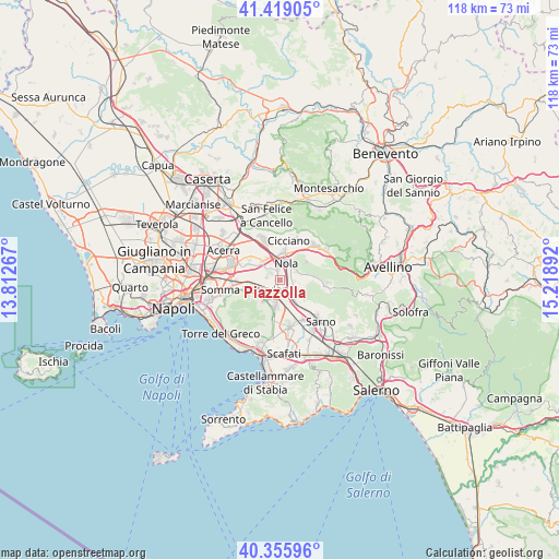
Piazzolla GPS coordinates[2]
40° 53' 22.704" North, 14° 30' 56.844" East
| Map corner | latitude | longitude |
|---|---|---|
| Upper-left | 41.41905°, | 13.81267° |
| Center: | 40.88964°, | 14.51579° |
| Lower-right: | 40.35596°, | 15.21892° |
| Map W x H: | 118.2×118.2 km | = 73.4×73.4mi |
| max Lat: | 47.04031° ⇑80.2% North |
| Piazzolla: | 40.88964° |
| min Lat: | ⇓19.8% South 35.50142° |
| min Long | Piazzolla | max Long |
| 6.69888° | 14.51579° | 18.48682° |
| W 82.8%⇐ | ⇒17.2% E |
Elevation
Elevation of Piazzolla is 54 m = 177 ft, and this is 252.7 m = 829 ft below average elevation for this country.
| Max E: |
2085 m = 6841 ft | 79% |
| Avg. | 306.7 m = 1006 ft | |
| Piazzolla | 54 m = 177 ft | |
Min E: |
-4 m = -13 ft | 21% |
See also: Italy elevation on elevation.city.
Geographical zone
Piazzolla is located in North temperate zone (between Tropic of Cancer and the Arctic Circle). Distance of this Northern Tropic circle is 1940.6 km =1205.8 mi to South.| Distance of | km | miles | from Piazzolla |
|---|---|---|---|
| North Pole | 5460.6 | 3393.1 | to North |
| Arctic Circle | 2854.7 | 1773.8 | to North |
| Tropic Cancer | 1940.6 | 1205.8 | to South |
| Equator | 4546.5 | 2825.1 | to South |


Nearby cities:
15 places around Piazzolla: (largest is in red/bold)
• Carbonara di Nola
5.6 km =3.5 mi,  107°
107°
• Casamarciano
5.7 km =3.5 mi,  33°
33°
• Liveri
4.5 km =2.8 mi,  68°
68°
• Nola
4.2 km =2.6 mi,  14°
14°
• Ottaviano
5.2 km =3.2 mi,  216°
216°
• Palma Campania
4 km =2.5 mi,  130°
130°
• Piazzola
2.3 km =1.4 mi,  214°
214°
• Pollastri
1.7 km =1.1 mi,  41°
41°
• San Gennaro Vesuviano
3.1 km =1.9 mi,  167°
167°
• San Paolo Bel Sito
3.8 km =2.4 mi,  46°
46°
• San Vitaliano
5.2 km =3.2 mi,  318°
318°
• Saviano
1.9 km =1.2 mi,  332°
332°
• Scisciano
4 km =2.5 mi,  298°
298°
• Spartimento
3.7 km =2.3 mi,  272°
272°
• Vico
4.8 km =3 mi, 112°
Sources, notices
• [Note1] Compared only with cities in Italy existing in our database
• [Src1] Map data: © OpenStreetMap contributors (CC-BY-SA)
• [Src2] Other city data from geonames.org with taken over terms of usage.
• [Src3] Geographical zone / Annual Mean Temperature by Robert A. Rohde @ Wikipedia
