Levice geodata
Levice (Piedmont) is a seat of a third-order administrative division; located in Italy in Europe/Rome (GMT+2) time zone. With population of 30 people, there are 11649 cities with bigger population in this country. Compared to other cities in Italy, 51.5% of cities are located further ↓South; 91.6% of cities are located further →East and 79.4% of cities have lower elevation than Levice. Note1


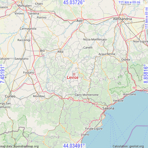
Levice GPS coordinates[2]
44° 32' 17.664" North, 8° 9' 18.144" East
| Map corner | latitude | longitude |
|---|---|---|
| Upper-left | 45.03726°, | 7.45191° |
| Center: | 44.53824°, | 8.15504° |
| Lower-right: | 44.03491°, | 8.85816° |
| Map W x H: | 111.5×111.4 km | = 69.3×69.2mi |
| max Lat: | 47.04031° ⇑48.5% North |
| Levice: | 44.53824° |
| min Lat: | ⇓51.5% South 35.50142° |
| min Long | Levice | max Long |
| 6.69888° | 8.15504° | 18.48682° |
| W 8.4%⇐ | ⇒91.6% E |
Elevation
Elevation of Levice is 516 m = 1693 ft, and this is 209.3 m = 687 ft above average elevation for this country.
| Max E: |
2085 m = 6841 ft | 20.6% |
| Levice | 516 m 1693 ft | |
| Avg. | 306.7 m = 1006 ft | |
Min E: |
-4 m = -13 ft | 79.4% |
See also: Italy elevation on elevation.city.
Geographical zone
Levice is located in North temperate zone (between Tropic of Cancer and the Arctic Circle). Distance of this Northern Tropic circle is 2346.3 km =1457.9 mi to South.| Distance of | km | miles | from Levice |
|---|---|---|---|
| North Pole | 5054.9 | 3141 | to North |
| Arctic Circle | 2449 | 1521.7 | to North |
| Tropic Cancer | 2346.3 | 1457.9 | to South |
| Equator | 4952.2 | 3077.2 | to South |


Nearby cities:
15 places around Levice: (largest is in red/bold)
• Arguello
6.1 km =3.8 mi,  324°
324°
• Bergolo
2.5 km =1.6 mi,  64°
64°
• Bosia
7.2 km =4.5 mi,  355°
355°
• Castelletto Uzzone
5.4 km =3.4 mi,  151°
151°
• Cerreto Langhe
6.1 km =3.8 mi,  311°
311°
• Cortemilia
5.6 km =3.5 mi,  33°
33°
• Cravanzana
4.6 km =2.9 mi,  331°
331°
• Feisoglio
4 km =2.5 mi,  278°
278°
• Gorzegno
3.3 km =2.1 mi,  209°
209°
• Niella Belbo
6.6 km =4.1 mi,  244°
244°
• Perletto
8.2 km =5.1 mi, 34°
• Pezzolo Valle Uzzone
3.1 km =1.9 mi,  88°
88°
• Prunetto
5.6 km =3.5 mi,  189°
189°
• Serravalle Langhe
8 km =5 mi,  287°
287°
• Torre Bormida
2.7 km =1.7 mi, 359°
Sources, notices
• [Note1] Compared only with cities in Italy existing in our database
• [Src1] Map data: © OpenStreetMap contributors (CC-BY-SA)
• [Src2] Other city data from geonames.org with taken over terms of usage.
• [Src3] Geographical zone / Annual Mean Temperature by Robert A. Rohde @ Wikipedia
