Leverano geodata
Leverano (Apulia) is a seat of a third-order administrative division; located in Italy in Europe/Rome (GMT+2) time zone. With population of 13,643 people, there are 670 cities with bigger population in this country. Compared to other cities in Italy, 85.7% of cities are located further ↑North; 98.9% of cities are located further ←West and 83.1% of cities have higher elevation than Leverano. Note1


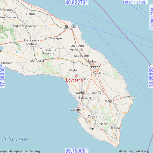
Leverano GPS coordinates[2]
40° 17' 18.672" North, 17° 59' 47.4" East
| Map corner | latitude | longitude |
|---|---|---|
| Upper-left | 40.82273°, | 17.29338° |
| Center: | 40.28852°, | 17.9965° |
| Lower-right: | 39.75005°, | 18.69963° |
| Map W x H: | 119.3×119.3 km | = 74.1×74.1mi |
| max Lat: | 47.04031° ⇑85.7% North |
| Leverano: | 40.28852° |
| min Lat: | ⇓14.3% South 35.50142° |
| min Long | Leverano | max Long |
| 6.69888° | 17.9965° | 18.48682° |
| W 98.9%⇐ | ⇒1.1% E |
Elevation
Elevation of Leverano is 37 m = 121 ft, and this is 269.7 m = 885 ft below average elevation for this country.
| Max E: |
2085 m = 6841 ft | 83.1% |
| Avg. | 306.7 m = 1006 ft | |
| Leverano | 37 m = 121 ft | |
Min E: |
-4 m = -13 ft | 16.9% |
See also: Italy elevation on elevation.city.
Geographical zone
Leverano is located in North temperate zone (between Tropic of Cancer and the Arctic Circle). Distance of this Northern Tropic circle is 1873.7 km =1164.3 mi to South.| Distance of | km | miles | from Leverano |
|---|---|---|---|
| North Pole | 5527.4 | 3434.6 | to North |
| Arctic Circle | 2921.5 | 1815.3 | to North |
| Tropic Cancer | 1873.7 | 1164.3 | to South |
| Equator | 4479.7 | 2783.6 | to South |


Nearby cities:
15 places around Leverano: (largest is in red/bold)
• Arnesano
9.7 km =6 mi,  56°
56°
• Campi Salentina
12.3 km =7.6 mi,  9°
9°
• Carmiano
7.3 km =4.5 mi,  31°
31°
• Collemeto
12.6 km =7.8 mi,  134°
134°
• Copertino
5.4 km =3.4 mi,  114°
114°
• Lequile
12.3 km =7.6 mi,  81°
81°
• Magliano
7.8 km =4.8 mi,  45°
45°
• Monteroni di Lecce
8.8 km =5.5 mi,  67°
67°
• Nardò
12.5 km =7.8 mi,  166°
166°
• Novoli
10.7 km =6.6 mi,  23°
23°
• Porto Cesareo
8.8 km =5.5 mi,  250°
250°
• Riesci
10.4 km =6.5 mi, 52°
• Salice Salentino
11.1 km =6.9 mi,  344°
344°
• San Pietro in Lama
11.3 km =7 mi, 79°
• Veglie
5.9 km =3.7 mi,  330°
330°
Sources, notices
• [Note1] Compared only with cities in Italy existing in our database
• [Src1] Map data: © OpenStreetMap contributors (CC-BY-SA)
• [Src2] Other city data from geonames.org with taken over terms of usage.
• [Src3] Geographical zone / Annual Mean Temperature by Robert A. Rohde @ Wikipedia
