Lequile geodata
Lequile (Apulia) is a seat of a third-order administrative division; located in Italy in Europe/Rome (GMT+2) time zone. With population of 8,137 people, there are 1190 cities with bigger population in this country. Compared to other cities in Italy, 85.5% of cities are located further ↑North; 99.2% of cities are located further ←West and 83.1% of cities have higher elevation than Lequile. Note1


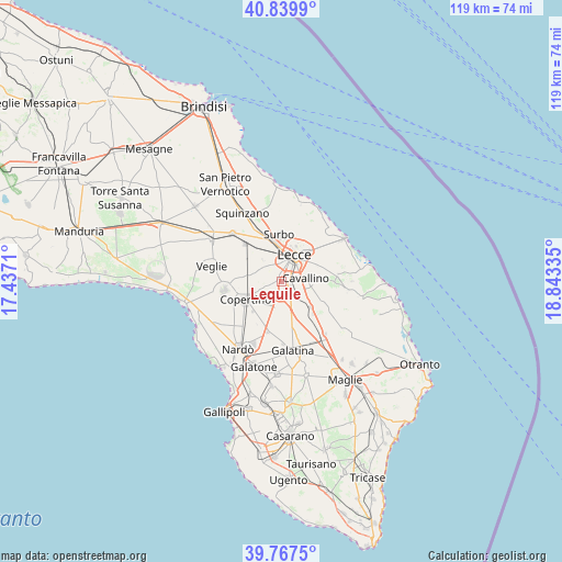
Lequile GPS coordinates[2]
40° 18' 20.988" North, 18° 8' 24.792" East
| Map corner | latitude | longitude |
|---|---|---|
| Upper-left | 40.8399°, | 17.4371° |
| Center: | 40.30583°, | 18.14022° |
| Lower-right: | 39.7675°, | 18.84335° |
| Map W x H: | 119.2×119.2 km | = 74.1×74.1mi |
| max Lat: | 47.04031° ⇑85.5% North |
| Lequile: | 40.30583° |
| min Lat: | ⇓14.5% South 35.50142° |
| min Long | Lequile | max Long |
| 6.69888° | 18.14022° | 18.48682° |
| W 99.2%⇐ | ⇒0.8% E |
Elevation
Elevation of Lequile is 37 m = 121 ft, and this is 269.7 m = 885 ft below average elevation for this country.
| Max E: |
2085 m = 6841 ft | 83.1% |
| Avg. | 306.7 m = 1006 ft | |
| Lequile | 37 m = 121 ft | |
Min E: |
-4 m = -13 ft | 16.9% |
See also: Italy elevation on elevation.city.
Geographical zone
Lequile is located in North temperate zone (between Tropic of Cancer and the Arctic Circle). Distance of this Northern Tropic circle is 1875.7 km =1165.5 mi to South.| Distance of | km | miles | from Lequile |
|---|---|---|---|
| North Pole | 5525.5 | 3433.4 | to North |
| Arctic Circle | 2919.6 | 1814.2 | to North |
| Tropic Cancer | 1875.7 | 1165.5 | to South |
| Equator | 4481.6 | 2784.7 | to South |


Nearby cities:
15 places around Lequile: (largest is in red/bold)
• Aria Sana
3.4 km =2.1 mi,  40°
40°
• Arnesano
5.4 km =3.4 mi,  309°
309°
• Castromediano
4.1 km =2.5 mi,  52°
52°
• Cavallino
5.3 km =3.3 mi,  84°
84°
• Complesso Agave
7.4 km =4.6 mi, 47°
• Galugnano
8.4 km =5.2 mi,  131°
131°
• Lecce
6.1 km =3.8 mi,  26°
26°
• Lizzanello
7 km =4.3 mi,  90°
90°
• Magliano
7.4 km =4.6 mi,  298°
298°
• Merine
7.8 km =4.8 mi,  66°
66°
• Monteroni di Lecce
4.4 km =2.7 mi,  289°
289°
• Riesci
5.9 km =3.7 mi,  317°
317°
• San Cesario di Lecce
1.8 km =1.1 mi,  102°
102°
• San Donato di Lecce
5.6 km =3.5 mi,  140°
140°
• San Pietro in Lama
1.1 km =0.7 mi,  277°
277°
Sources, notices
• [Note1] Compared only with cities in Italy existing in our database
• [Src1] Map data: © OpenStreetMap contributors (CC-BY-SA)
• [Src2] Other city data from geonames.org with taken over terms of usage.
• [Src3] Geographical zone / Annual Mean Temperature by Robert A. Rohde @ Wikipedia
