Lamporecchio geodata
Lamporecchio (Tuscany) is a seat of a third-order administrative division; located in Italy in Europe/Rome (GMT+2) time zone. With population of 5,179 people, there are 1888 cities with bigger population in this country. Compared to other cities in Italy, 56.9% of cities are located further ↑North; 58.8% of cities are located further →East and 83.7% of cities have higher elevation than Lamporecchio. Note1


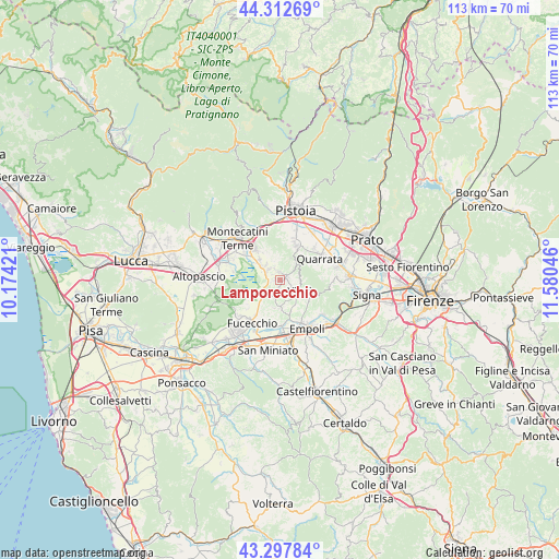
Lamporecchio GPS coordinates[2]
43° 48' 26.712" North, 10° 52' 38.388" East
| Map corner | latitude | longitude |
|---|---|---|
| Upper-left | 44.31269°, | 10.17421° |
| Center: | 43.80742°, | 10.87733° |
| Lower-right: | 43.29784°, | 11.58046° |
| Map W x H: | 112.8×112.8 km | = 70.1×70.1mi |
| max Lat: | 47.04031° ⇑56.9% North |
| Lamporecchio: | 43.80742° |
| min Lat: | ⇓43.1% South 35.50142° |
| min Long | Lamporecchio | max Long |
| 6.69888° | 10.87733° | 18.48682° |
| W 41.2%⇐ | ⇒58.8% E |
Elevation
Elevation of Lamporecchio is 35 m = 115 ft, and this is 271.7 m = 891 ft below average elevation for this country.
| Max E: |
2085 m = 6841 ft | 83.7% |
| Avg. | 306.7 m = 1006 ft | |
| Lamporecchio | 35 m = 115 ft | |
Min E: |
-4 m = -13 ft | 16.3% |
See also: Italy elevation on elevation.city.
Geographical zone
Lamporecchio is located in North temperate zone (between Tropic of Cancer and the Arctic Circle). Distance of this Northern Tropic circle is 2265 km =1407.4 mi to South.| Distance of | km | miles | from Lamporecchio |
|---|---|---|---|
| North Pole | 5136.1 | 3191.4 | to North |
| Arctic Circle | 2530.2 | 1572.2 | to North |
| Tropic Cancer | 2265 | 1407.4 | to South |
| Equator | 4870.9 | 3026.6 | to South |


Nearby cities:
15 places around Lamporecchio: (largest is in red/bold)
• Cantagrillo-Casalguidi
7.5 km =4.7 mi,  23°
23°
• Cerreto Guidi
5.5 km =3.4 mi,  176°
176°
• Cintolese
5.9 km =3.7 mi,  316°
316°
• Fornace-Torribina
5.5 km =3.4 mi,  194°
194°
• Larciano
3.1 km =1.9 mi, 19°
• Lazzeretto
3 km =1.9 mi,  206°
206°
• Monsummano Terme
8.4 km =5.2 mi, 322°
• Pozzarello
6.6 km =4.1 mi,  327°
327°
• San Baronto
4.7 km =2.9 mi,  45°
45°
• San Rocco
2.2 km =1.4 mi, 323°
• Santonuovo
8.3 km =5.2 mi,  39°
39°
• Stabbia
4.4 km =2.7 mi,  231°
231°
• Uggia-Pazzera-Bizzarrino
4.7 km =2.9 mi,  309°
309°
• Vinci
4.7 km =2.9 mi,  127°
127°
• Vitolini
7 km =4.3 mi,  116°
116°
Sources, notices
• [Note1] Compared only with cities in Italy existing in our database
• [Src1] Map data: © OpenStreetMap contributors (CC-BY-SA)
• [Src2] Other city data from geonames.org with taken over terms of usage.
• [Src3] Geographical zone / Annual Mean Temperature by Robert A. Rohde @ Wikipedia
