Lagosanto geodata
Lagosanto (Emilia-Romagna) is a seat of a third-order administrative division; located in Italy in Europe/Rome (GMT+2) time zone. With population of 4,026 people, there are 2378 cities with bigger population in this country. Compared to other cities in Italy, 55.5% of cities are located further ↓South; 57.9% of cities are located further ←West and 99.7% of cities have higher elevation than Lagosanto. Note1
Administrative division(s):
- Level 1: Emilia-Romagna
- Level 2: Provincia di Ferrara
- Level 3: Lagosanto


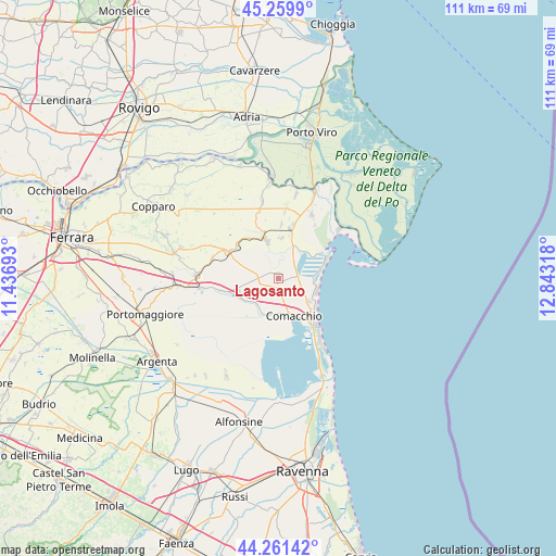
Lagosanto GPS coordinates[2]
44° 45' 46.152" North, 12° 8' 24.18" East
| Map corner | latitude | longitude |
|---|---|---|
| Upper-left | 45.2599°, | 11.43693° |
| Center: | 44.76282°, | 12.14005° |
| Lower-right: | 44.26142°, | 12.84318° |
| Map W x H: | 111×111 km | = 69×69mi |
| max Lat: | 47.04031° ⇑44.5% North |
| Lagosanto: | 44.76282° |
| min Lat: | ⇓55.5% South 35.50142° |
| min Long | Lagosanto | max Long |
| 6.69888° | 12.14005° | 18.48682° |
| W 57.9%⇐ | ⇒42.1% E |
Elevation
Elevation of Lagosanto is 0 m = 0 ft, and this is 306.7 m = 1006 ft below average elevation for this country.
| Max E: |
2085 m = 6841 ft | 99.7% |
| Avg. | 306.7 m = 1006 ft | |
| Lagosanto | 0 m = 0 ft | |
Min E: |
-4 m = -13 ft | 0.3% |
See also: Italy elevation on elevation.city.
Geographical zone
Lagosanto is located in North temperate zone (between Tropic of Cancer and the Arctic Circle). Distance of this Northern Tropic circle is 2371.2 km =1473.4 mi to South.| Distance of | km | miles | from Lagosanto |
|---|---|---|---|
| North Pole | 5029.9 | 3125.4 | to North |
| Arctic Circle | 2424 | 1506.2 | to North |
| Tropic Cancer | 2371.2 | 1473.4 | to South |
| Equator | 4977.2 | 3092.7 | to South |


Nearby cities:
15 places around Lagosanto: (largest is in red/bold)
• Bosco Mesola
14.5 km =9 mi,  29°
29°
• Codigoro
7.9 km =4.9 mi,  343°
343°
• Comacchio
8.3 km =5.2 mi,  156°
156°
• Lido degli Estensi
13.8 km =8.6 mi,  140°
140°
• Lido delle Nazioni
8.1 km =5 mi,  107°
107°
• Lido di Pomposa-Lido degli Scacchi
9.8 km =6.1 mi,  129°
129°
• Lido di Spina
15.3 km =9.5 mi,  145°
145°
• Massa Fiscaglia
11.7 km =7.3 mi,  296°
296°
• Migliaro
13.7 km =8.5 mi,  287°
287°
• Ostellato
15.7 km =9.8 mi,  262°
262°
• Pontelangorino
10.9 km =6.8 mi,  3°
3°
• Pontemaodino
7.9 km =4.9 mi,  5°
5°
• Porto Garibaldi
11.9 km =7.4 mi, 139°
• San Giovanni
8.2 km =5.1 mi,  240°
240°
• San Giuseppe
7.6 km =4.7 mi, 126°
Sources, notices
• [Note1] Compared only with cities in Italy existing in our database
• [Src1] Map data: © OpenStreetMap contributors (CC-BY-SA)
• [Src2] Other city data from geonames.org with taken over terms of usage.
• [Src3] Geographical zone / Annual Mean Temperature by Robert A. Rohde @ Wikipedia
