Migliaro geodata
Migliaro (Emilia-Romagna) is a seat of a third-order administrative division; located in Italy in Europe/Rome (GMT+2) time zone. With population of 1,728 people, there are 4614 cities with bigger population in this country. Compared to other cities in Italy, 56.1% of cities are located further ↓South; 55.5% of cities are located further ←West and 99.7% of cities have higher elevation than Migliaro. Note1
Administrative division(s):
- Level 1: Emilia-Romagna
- Level 2: Provincia di Ferrara
- Level 3: Fiscaglia


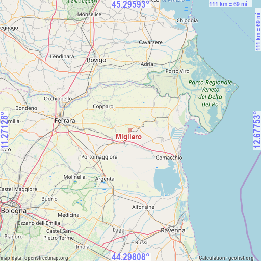
Migliaro GPS coordinates[2]
44° 47' 56.976" North, 11° 58' 27.84" East
| Map corner | latitude | longitude |
|---|---|---|
| Upper-left | 45.29593°, | 11.27128° |
| Center: | 44.79916°, | 11.9744° |
| Lower-right: | 44.29808°, | 12.67753° |
| Map W x H: | 111×110.9 km | = 69×68.9mi |
| max Lat: | 47.04031° ⇑43.9% North |
| Migliaro: | 44.79916° |
| min Lat: | ⇓56.1% South 35.50142° |
| min Long | Migliaro | max Long |
| 6.69888° | 11.9744° | 18.48682° |
| W 55.5%⇐ | ⇒44.5% E |
Elevation
Elevation of Migliaro is 0 m = 0 ft, and this is 306.7 m = 1006 ft below average elevation for this country.
| Max E: |
2085 m = 6841 ft | 99.7% |
| Avg. | 306.7 m = 1006 ft | |
| Migliaro | 0 m = 0 ft | |
Min E: |
-4 m = -13 ft | 0.3% |
See also: Italy elevation on elevation.city.
Geographical zone
Migliaro is located in North temperate zone (between Tropic of Cancer and the Arctic Circle). Distance of this Northern Tropic circle is 2375.3 km =1475.9 mi to South.| Distance of | km | miles | from Migliaro |
|---|---|---|---|
| North Pole | 5025.9 | 3122.9 | to North |
| Arctic Circle | 2420 | 1503.7 | to North |
| Tropic Cancer | 2375.3 | 1475.9 | to South |
| Equator | 4981.2 | 3095.2 | to South |


Nearby cities:
15 places around Migliaro: (largest is in red/bold)
• Ambrogio
13.4 km =8.3 mi,  338°
338°
• Codigoro
11.3 km =7 mi,  71°
71°
• Dogato
8.8 km =5.5 mi,  230°
230°
• Formignana
10.3 km =6.4 mi,  297°
297°
• Jolanda di Savoia
9.4 km =5.8 mi,  2°
2°
• Lagosanto
13.7 km =8.5 mi,  107°
107°
• Masi-Torello
13.6 km =8.5 mi,  267°
267°
• Massa Fiscaglia
2.9 km =1.8 mi, 65°
• Mezzogoro
15.1 km =9.4 mi,  40°
40°
• Migliarino
4.6 km =2.9 mi, 225°
• Ostellato
6.5 km =4 mi,  202°
202°
• Pontelangorino
15.4 km =9.6 mi,  63°
63°
• Pontemaodino
14.4 km =8.9 mi, 74°
• San Giovanni
10 km =6.2 mi,  143°
143°
• Tresigallo-Final di Rero
6.6 km =4.1 mi,  286°
286°
Sources, notices
• [Note1] Compared only with cities in Italy existing in our database
• [Src1] Map data: © OpenStreetMap contributors (CC-BY-SA)
• [Src2] Other city data from geonames.org with taken over terms of usage.
• [Src3] Geographical zone / Annual Mean Temperature by Robert A. Rohde @ Wikipedia
