Guardiagrele geodata
Guardiagrele (Abruzzo) is a seat of a third-order administrative division; located in Italy in Europe/Rome (GMT+2) time zone. With population of 4,789 people, there are 2041 cities with bigger population in this country. Compared to other cities in Italy, 68.8% of cities are located further ↑North; 80% of cities are located further ←West and 80.5% of cities have lower elevation than Guardiagrele. Note1


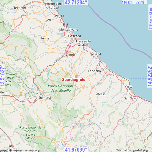
Guardiagrele GPS coordinates[2]
42° 11' 38.616" North, 14° 13' 9.804" East
| Map corner | latitude | longitude |
|---|---|---|
| Upper-left | 42.71284°, | 13.51627° |
| Center: | 42.19406°, | 14.21939° |
| Lower-right: | 41.67099°, | 14.92252° |
| Map W x H: | 115.8×115.8 km | = 72×72mi |
| max Lat: | 47.04031° ⇑68.8% North |
| Guardiagrele: | 42.19406° |
| min Lat: | ⇓31.2% South 35.50142° |
| min Long | Guardiagrele | max Long |
| 6.69888° | 14.21939° | 18.48682° |
| W 80%⇐ | ⇒20% E |
Elevation
Elevation of Guardiagrele is 532 m = 1745 ft, and this is 225.3 m = 739 ft above average elevation for this country.
| Max E: |
2085 m = 6841 ft | 19.5% |
| Guardiagrele | 532 m 1745 ft | |
| Avg. | 306.7 m = 1006 ft | |
Min E: |
-4 m = -13 ft | 80.5% |
See also: Italy elevation on elevation.city.
Geographical zone
Guardiagrele is located in North temperate zone (between Tropic of Cancer and the Arctic Circle). Distance of this Northern Tropic circle is 2085.6 km =1295.9 mi to South.| Distance of | km | miles | from Guardiagrele |
|---|---|---|---|
| North Pole | 5315.5 | 3302.9 | to North |
| Arctic Circle | 2709.6 | 1683.7 | to North |
| Tropic Cancer | 2085.6 | 1295.9 | to South |
| Equator | 4691.5 | 2915.2 | to South |


Nearby cities:
15 places around Guardiagrele: (largest is in red/bold)
• Ari
11.1 km =6.9 mi,  16°
16°
• Arielli
10.5 km =6.5 mi,  45°
45°
• Casacanditella
6 km =3.7 mi,  344°
344°
• Casoli
10.7 km =6.6 mi,  146°
146°
• Fara Filiorum Petri
6.2 km =3.9 mi,  328°
328°
• Filetto
4.5 km =2.8 mi,  28°
28°
• Orsogna
6 km =3.7 mi,  57°
57°
• Palombaro
7.9 km =4.9 mi,  173°
173°
• Pennapiedimonte
4.7 km =2.9 mi,  205°
205°
• Poggiofiorito
10.7 km =6.6 mi, 51°
• Pretoro
6.9 km =4.3 mi,  293°
293°
• Rapino
3.3 km =2.1 mi,  300°
300°
• San Martino sulla Marrucina
3.4 km =2.1 mi,  354°
354°
• San Rocco
9.2 km =5.7 mi,  306°
306°
• Sant'Eusanio del Sangro
9.4 km =5.8 mi,  107°
107°
Sources, notices
• [Note1] Compared only with cities in Italy existing in our database
• [Src1] Map data: © OpenStreetMap contributors (CC-BY-SA)
• [Src2] Other city data from geonames.org with taken over terms of usage.
• [Src3] Geographical zone / Annual Mean Temperature by Robert A. Rohde @ Wikipedia
