Ari geodata
Ari (Abruzzo) is a seat of a third-order administrative division; located in Italy in Europe/Rome (GMT+2) time zone. With population of 482 people, there are 9987 cities with bigger population in this country. Compared to other cities in Italy, 67.9% of cities are located further ↑North; 80.5% of cities are located further ←West and 58.7% of cities have lower elevation than Ari. Note1


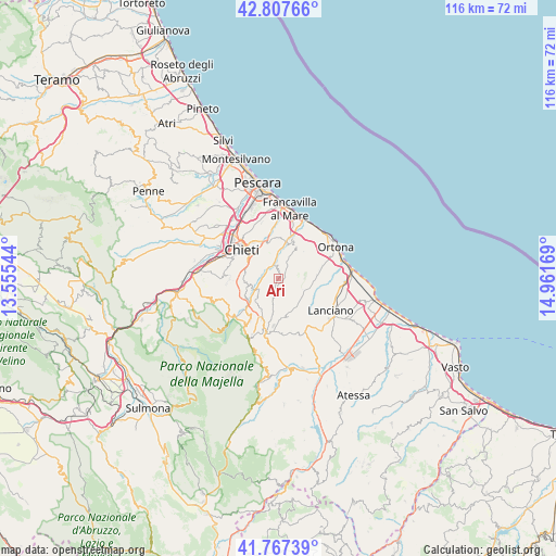
Ari GPS coordinates[2]
42° 17' 22.812" North, 14° 15' 30.816" East
| Map corner | latitude | longitude |
|---|---|---|
| Upper-left | 42.80766°, | 13.55544° |
| Center: | 42.28967°, | 14.25856° |
| Lower-right: | 41.76739°, | 14.96169° |
| Map W x H: | 115.7×115.7 km | = 71.9×71.9mi |
| max Lat: | 47.04031° ⇑67.9% North |
| Ari: | 42.28967° |
| min Lat: | ⇓32.1% South 35.50142° |
| min Long | Ari | max Long |
| 6.69888° | 14.25856° | 18.48682° |
| W 80.5%⇐ | ⇒19.5% E |
Elevation
Elevation of Ari is 290 m = 951 ft, and this is 16.7 m = 55 ft below average elevation for this country.
| Max E: |
2085 m = 6841 ft | 41.3% |
| Avg. | 306.7 m = 1006 ft | |
| Ari | 290 m = 951 ft | |
Min E: |
-4 m = -13 ft | 58.7% |
See also: Italy elevation on elevation.city.
Geographical zone
Ari is located in North temperate zone (between Tropic of Cancer and the Arctic Circle). Distance of this Northern Tropic circle is 2096.3 km =1302.6 mi to South.| Distance of | km | miles | from Ari |
|---|---|---|---|
| North Pole | 5304.9 | 3296.3 | to North |
| Arctic Circle | 2699 | 1677.1 | to North |
| Tropic Cancer | 2096.3 | 1302.6 | to South |
| Equator | 4702.2 | 2921.8 | to South |


Nearby cities:
15 places around Ari: (largest is in red/bold)
• Arielli
5.4 km =3.4 mi,  127°
127°
• Bucchianico
6.3 km =3.9 mi,  284°
284°
• Canosa Sannita
3.9 km =2.4 mi,  79°
79°
• Casacanditella
6.8 km =4.2 mi,  224°
224°
• Crecchio
5.7 km =3.5 mi, 80°
• Fara Filiorum Petri
8.4 km =5.2 mi,  230°
230°
• Filetto
6.8 km =4.2 mi,  189°
189°
• Giuliano Teatino
3.1 km =1.9 mi,  36°
36°
• Miglianico
8 km =5 mi,  19°
19°
• Orsogna
7.6 km =4.7 mi,  166°
166°
• Poggiofiorito
6.5 km =4 mi, 127°
• San Martino sulla Marrucina
8.1 km =5 mi,  205°
205°
• Tollo
8.2 km =5.1 mi, 40°
• Vacri
2.6 km =1.6 mi,  290°
290°
• Villamagna
4.8 km =3 mi,  338°
338°
Sources, notices
• [Note1] Compared only with cities in Italy existing in our database
• [Src1] Map data: © OpenStreetMap contributors (CC-BY-SA)
• [Src2] Other city data from geonames.org with taken over terms of usage.
• [Src3] Geographical zone / Annual Mean Temperature by Robert A. Rohde @ Wikipedia
