Grottaglie geodata
Grottaglie (Apulia) is a seat of a third-order administrative division; located in Italy in Europe/Rome (GMT+2) time zone. With population of 31,320 people, there are 257 cities with bigger population in this country. Compared to other cities in Italy, 83.9% of cities are located further ↑North; 98.6% of cities are located further ←West and 63.1% of cities have higher elevation than Grottaglie. Note1


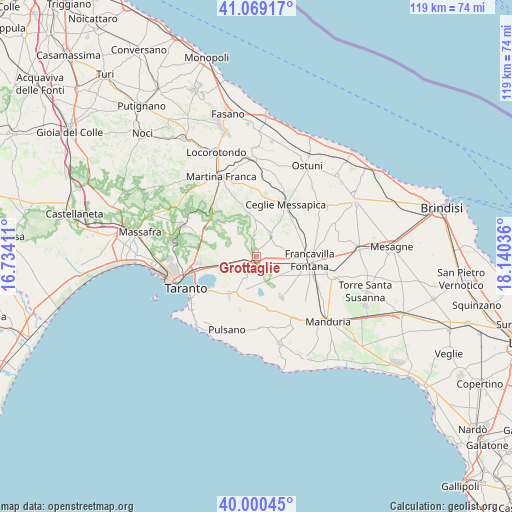
Grottaglie GPS coordinates[2]
40° 32' 12.984" North, 17° 26' 14.028" East
| Map corner | latitude | longitude |
|---|---|---|
| Upper-left | 41.06917°, | 16.73411° |
| Center: | 40.53694°, | 17.43723° |
| Lower-right: | 40.00045°, | 18.14036° |
| Map W x H: | 118.8×118.8 km | = 73.8×73.8mi |
| max Lat: | 47.04031° ⇑83.9% North |
| Grottaglie: | 40.53694° |
| min Lat: | ⇓16.1% South 35.50142° |
| min Long | Grottaglie | max Long |
| 6.69888° | 17.43723° | 18.48682° |
| W 98.6%⇐ | ⇒1.4% E |
Elevation
Elevation of Grottaglie is 140 m = 459 ft, and this is 166.7 m = 547 ft below average elevation for this country.
| Max E: |
2085 m = 6841 ft | 63.1% |
| Avg. | 306.7 m = 1006 ft | |
| Grottaglie | 140 m = 459 ft | |
Min E: |
-4 m = -13 ft | 36.9% |
See also: Italy elevation on elevation.city.
Geographical zone
Grottaglie is located in North temperate zone (between Tropic of Cancer and the Arctic Circle). Distance of this Northern Tropic circle is 1901.4 km =1181.5 mi to South.| Distance of | km | miles | from Grottaglie |
|---|---|---|---|
| North Pole | 5499.8 | 3417.4 | to North |
| Arctic Circle | 2893.9 | 1798.2 | to North |
| Tropic Cancer | 1901.4 | 1181.5 | to South |
| Equator | 4507.3 | 2800.7 | to South |


Nearby cities:
15 places around Grottaglie: (largest is in red/bold)
• Carosino
8.6 km =5.3 mi,  202°
202°
• Ceglie Messapica
13.9 km =8.6 mi,  28°
28°
• Faggiano
14 km =8.7 mi, 197°
• Fragagnano
12.3 km =7.6 mi,  164°
164°
• Francavilla Fontana
12.5 km =7.8 mi,  92°
92°
• Lizzano
16 km =9.9 mi,  177°
177°
• Monteiasi
6.2 km =3.9 mi,  228°
228°
• Montemesola
9.2 km =5.7 mi,  291°
291°
• Monteparano
10.6 km =6.6 mi,  191°
191°
• Oria
17.9 km =11.1 mi,  103°
103°
• Paolo VI
13.9 km =8.6 mi,  263°
263°
• Roccaforzata
11.8 km =7.3 mi, 199°
• San Giorgio Ionico
10 km =6.2 mi,  208°
208°
• San Marzano di San Giuseppe
10.7 km =6.6 mi,  148°
148°
• Villa Castelli
6 km =3.7 mi, 31°
Sources, notices
• [Note1] Compared only with cities in Italy existing in our database
• [Src1] Map data: © OpenStreetMap contributors (CC-BY-SA)
• [Src2] Other city data from geonames.org with taken over terms of usage.
• [Src3] Geographical zone / Annual Mean Temperature by Robert A. Rohde @ Wikipedia
