Golasecca geodata
Golasecca (Lombardy) is a seat of a third-order administrative division; located in Italy in Europe/Rome (GMT+2) time zone. With population of 2,404 people, there are 3632 cities with bigger population in this country. Compared to other cities in Italy, 81.1% of cities are located further ↓South; 86% of cities are located further →East and 57% of cities have lower elevation than Golasecca. Note1


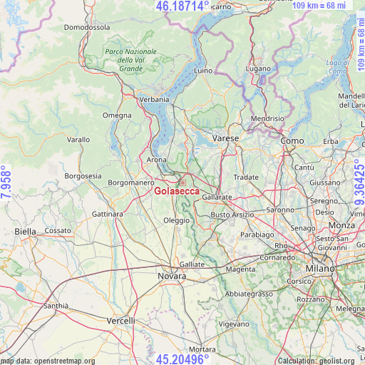
Golasecca GPS coordinates[2]
45° 41' 53.556" North, 8° 39' 40.032" East
| Map corner | latitude | longitude |
|---|---|---|
| Upper-left | 46.18714°, | 7.958° |
| Center: | 45.69821°, | 8.66112° |
| Lower-right: | 45.20496°, | 9.36425° |
| Map W x H: | 109.2×109.2 km | = 67.9×67.9mi |
| max Lat: | 47.04031° ⇑18.9% North |
| Golasecca: | 45.69821° |
| min Lat: | ⇓81.1% South 35.50142° |
| min Long | Golasecca | max Long |
| 6.69888° | 8.66112° | 18.48682° |
| W 14%⇐ | ⇒86% E |
Elevation
Elevation of Golasecca is 278 m = 912 ft, and this is 28.7 m = 94 ft below average elevation for this country.
| Max E: |
2085 m = 6841 ft | 43% |
| Avg. | 306.7 m = 1006 ft | |
| Golasecca | 278 m = 912 ft | |
Min E: |
-4 m = -13 ft | 57% |
See also: Italy elevation on elevation.city.
Geographical zone
Golasecca is located in North temperate zone (between Tropic of Cancer and the Arctic Circle). Distance of this North polar circle is 2320 km =1441.6 mi to North.| Distance of | km | miles | from Golasecca |
|---|---|---|---|
| North Pole | 4925.9 | 3060.8 | to North |
| Arctic Circle | 2320 | 1441.6 | to North |
| Tropic Cancer | 2475.2 | 1538 | to South |
| Equator | 5081.2 | 3157.3 | to South |


Nearby cities:
15 places around Golasecca: (largest is in red/bold)
• Arsago Seprio
5.9 km =3.7 mi,  101°
101°
• Borgo Ticino
4.5 km =2.8 mi,  257°
257°
• Castelletto Sopra Ticino
3.2 km =2 mi,  318°
318°
• Cimbro
6.2 km =3.9 mi,  47°
47°
• Coarezza
2.3 km =1.4 mi,  214°
214°
• Corgeno
5.7 km =3.5 mi,  21°
21°
• Divignano
6.2 km =3.9 mi,  230°
230°
• Lisanza
6.7 km =4.2 mi,  313°
313°
• Maddalena
4.4 km =2.7 mi,  156°
156°
• Mercallo
5.6 km =3.5 mi,  7°
7°
• Pombia
5.4 km =3.4 mi, 208°
• Sesto Calende
3.7 km =2.3 mi,  325°
325°
• Somma Lombardo
4 km =2.5 mi,  116°
116°
• Varallo Pombia
4.2 km =2.6 mi,  216°
216°
• Vergiate
3.8 km =2.4 mi,  44°
44°
Sources, notices
• [Note1] Compared only with cities in Italy existing in our database
• [Src1] Map data: © OpenStreetMap contributors (CC-BY-SA)
• [Src2] Other city data from geonames.org with taken over terms of usage.
• [Src3] Geographical zone / Annual Mean Temperature by Robert A. Rohde @ Wikipedia
