Sesto Calende geodata
Sesto Calende (Lombardy) is a seat of a third-order administrative division; located in Italy in Europe/Rome (GMT+2) time zone. With population of 8,434 people, there are 1136 cities with bigger population in this country. Compared to other cities in Italy, 82.5% of cities are located further ↓South; 86.3% of cities are located further →East and 54.4% of cities have higher elevation than Sesto Calende. Note1


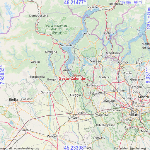
Sesto Calende GPS coordinates[2]
45° 43' 33.888" North, 8° 38' 2.292" East
| Map corner | latitude | longitude |
|---|---|---|
| Upper-left | 46.21477°, | 7.93085° |
| Center: | 45.72608°, | 8.63397° |
| Lower-right: | 45.23308°, | 9.3371° |
| Map W x H: | 109.2×109.2 km | = 67.9×67.9mi |
| max Lat: | 47.04031° ⇑17.5% North |
| Sesto Calende: | 45.72608° |
| min Lat: | ⇓82.5% South 35.50142° |
| min Long | Sesto Calende | max Long |
| 6.69888° | 8.63397° | 18.48682° |
| W 13.7%⇐ | ⇒86.3% E |
Elevation
Elevation of Sesto Calende is 206 m = 676 ft, and this is 100.7 m = 330 ft below average elevation for this country.
| Max E: |
2085 m = 6841 ft | 54.4% |
| Avg. | 306.7 m = 1006 ft | |
| Sesto Calende | 206 m = 676 ft | |
Min E: |
-4 m = -13 ft | 45.6% |
See also: Italy elevation on elevation.city.
Geographical zone
Sesto Calende is located in North temperate zone (between Tropic of Cancer and the Arctic Circle). Distance of this North polar circle is 2316.9 km =1439.7 mi to North.| Distance of | km | miles | from Sesto Calende |
|---|---|---|---|
| North Pole | 4922.8 | 3058.9 | to North |
| Arctic Circle | 2316.9 | 1439.7 | to North |
| Tropic Cancer | 2478.3 | 1539.9 | to South |
| Equator | 5084.3 | 3159.2 | to South |


Nearby cities:
15 places around Sesto Calende: (largest is in red/bold)
• Arona
7 km =4.3 mi,  301°
301°
• Borgo Ticino
4.7 km =2.9 mi,  209°
209°
• Castelletto Sopra Ticino
0.7 km =0.4 mi,  182°
182°
• Cimbro
6.8 km =4.2 mi,  80°
80°
• Coarezza
5 km =3.1 mi,  170°
170°
• Comabbio
6.3 km =3.9 mi,  33°
33°
• Comignago
5.6 km =3.5 mi,  257°
257°
• Corgeno
4.7 km =2.9 mi,  62°
62°
• Dormelletto
5.3 km =3.3 mi,  282°
282°
• Golasecca
3.7 km =2.3 mi,  145°
145°
• Lisanza
3.1 km =1.9 mi, 298°
• Mercallo
3.7 km =2.3 mi,  49°
49°
• Taino
4.3 km =2.7 mi,  341°
341°
• Varallo Pombia
6.5 km =4 mi, 183°
• Vergiate
4.8 km =3 mi,  95°
95°
Sources, notices
• [Note1] Compared only with cities in Italy existing in our database
• [Src1] Map data: © OpenStreetMap contributors (CC-BY-SA)
• [Src2] Other city data from geonames.org with taken over terms of usage.
• [Src3] Geographical zone / Annual Mean Temperature by Robert A. Rohde @ Wikipedia
