Giuggianello geodata
Giuggianello (Apulia) is a seat of a third-order administrative division; located in Italy in Europe/Rome (GMT+2) time zone. With population of 1,249 people, there are 5791 cities with bigger population in this country. Compared to other cities in Italy, 87.2% of cities are located further ↑North; 99.8% of cities are located further ←West and 73.6% of cities have higher elevation than Giuggianello. Note1


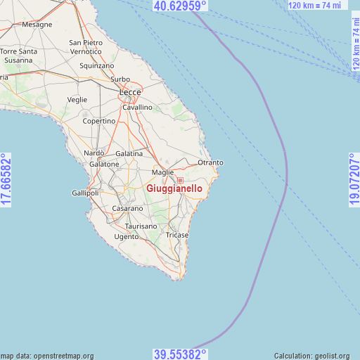
Giuggianello GPS coordinates[2]
40° 5' 37.788" North, 18° 22' 8.184" East
| Map corner | latitude | longitude |
|---|---|---|
| Upper-left | 40.62959°, | 17.66582° |
| Center: | 40.09383°, | 18.36894° |
| Lower-right: | 39.55382°, | 19.07207° |
| Map W x H: | 119.6×119.6 km | = 74.3×74.3mi |
| max Lat: | 47.04031° ⇑87.2% North |
| Giuggianello: | 40.09383° |
| min Lat: | ⇓12.8% South 35.50142° |
| min Long | Giuggianello | max Long |
| 6.69888° | 18.36894° | 18.48682° |
| W 99.8%⇐ | ⇒0.2% E |
Elevation
Elevation of Giuggianello is 80 m = 262 ft, and this is 226.7 m = 744 ft below average elevation for this country.
| Max E: |
2085 m = 6841 ft | 73.6% |
| Avg. | 306.7 m = 1006 ft | |
| Giuggianello | 80 m = 262 ft | |
Min E: |
-4 m = -13 ft | 26.4% |
See also: Italy elevation on elevation.city.
Geographical zone
Giuggianello is located in North temperate zone (between Tropic of Cancer and the Arctic Circle). Distance of this Northern Tropic circle is 1852.1 km =1150.8 mi to South.| Distance of | km | miles | from Giuggianello |
|---|---|---|---|
| North Pole | 5549 | 3448 | to North |
| Arctic Circle | 2943.2 | 1828.8 | to North |
| Tropic Cancer | 1852.1 | 1150.8 | to South |
| Equator | 4458 | 2770.1 | to South |


Nearby cities:
15 places around Giuggianello: (largest is in red/bold)
• Bagnolo del Salento
6.3 km =3.9 mi,  346°
346°
• Botrugno
5.2 km =3.2 mi,  229°
229°
• Cocumola
6 km =3.7 mi,  120°
120°
• Giurdignano
6.3 km =3.9 mi,  58°
58°
• Maglie
6.7 km =4.2 mi,  296°
296°
• Minervino di Lecce
4.5 km =2.8 mi,  95°
95°
• Muro Leccese
2.9 km =1.8 mi,  290°
290°
• Ortelle
6.9 km =4.3 mi,  164°
164°
• Palmariggi
4.2 km =2.6 mi,  11°
11°
• Poggiardo
4.6 km =2.9 mi,  170°
170°
• San Cassiano
5.1 km =3.2 mi,  215°
215°
• Sanarica
1.9 km =1.2 mi,  253°
253°
• Scorrano
5.9 km =3.7 mi,  266°
266°
• Uggiano la Chiesa
6.8 km =4.2 mi,  83°
83°
• Vitigliano
7.1 km =4.4 mi,  148°
148°
Sources, notices
• [Note1] Compared only with cities in Italy existing in our database
• [Src1] Map data: © OpenStreetMap contributors (CC-BY-SA)
• [Src2] Other city data from geonames.org with taken over terms of usage.
• [Src3] Geographical zone / Annual Mean Temperature by Robert A. Rohde @ Wikipedia
