Ortelle geodata
Ortelle (Apulia) is a seat of a third-order administrative division; located in Italy in Europe/Rome (GMT+2) time zone. With population of 1,009 people, there are 6631 cities with bigger population in this country. Compared to other cities in Italy, 87.7% of cities are located further ↑North; 99.9% of cities are located further ←West and 69.9% of cities have higher elevation than Ortelle. Note1


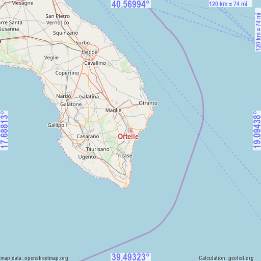
Ortelle GPS coordinates[2]
40° 2' 1.356" North, 18° 23' 28.5" East
| Map corner | latitude | longitude |
|---|---|---|
| Upper-left | 40.56994°, | 17.68813° |
| Center: | 40.03371°, | 18.39125° |
| Lower-right: | 39.49323°, | 19.09438° |
| Map W x H: | 119.7×119.7 km | = 74.4×74.4mi |
| max Lat: | 47.04031° ⇑87.7% North |
| Ortelle: | 40.03371° |
| min Lat: | ⇓12.3% South 35.50142° |
| min Long | Ortelle | max Long |
| 6.69888° | 18.39125° | 18.48682° |
| W 99.9%⇐ | ⇒0.099999999999994% E |
Elevation
Elevation of Ortelle is 98 m = 322 ft, and this is 208.7 m = 685 ft below average elevation for this country.
| Max E: |
2085 m = 6841 ft | 69.9% |
| Avg. | 306.7 m = 1006 ft | |
| Ortelle | 98 m = 322 ft | |
Min E: |
-4 m = -13 ft | 30.1% |
See also: Italy elevation on elevation.city.
Geographical zone
Ortelle is located in North temperate zone (between Tropic of Cancer and the Arctic Circle). Distance of this Northern Tropic circle is 1845.4 km =1146.7 mi to South.| Distance of | km | miles | from Ortelle |
|---|---|---|---|
| North Pole | 5555.7 | 3452.2 | to North |
| Arctic Circle | 2949.8 | 1832.9 | to North |
| Tropic Cancer | 1845.4 | 1146.7 | to South |
| Equator | 4451.3 | 2765.9 | to South |


Nearby cities:
15 places around Ortelle: (largest is in red/bold)
• Andrano
5.4 km =3.4 mi,  188°
188°
• Castiglione
6.6 km =4.1 mi,  212°
212°
• Castro
4.2 km =2.6 mi,  135°
135°
• Cerfignano
5.3 km =3.3 mi,  55°
55°
• Cocumola
4.9 km =3 mi,  42°
42°
• Diso
2.7 km =1.7 mi,  179°
179°
• Marittima
4.2 km =2.6 mi,  171°
171°
• Nociglia
5.4 km =3.4 mi,  275°
275°
• Poggiardo
2.4 km =1.5 mi,  332°
332°
• San Cassiano
5.5 km =3.4 mi,  297°
297°
• Santa Cesarea Terme
5.5 km =3.4 mi,  87°
87°
• Spongano
2.8 km =1.7 mi,  230°
230°
• Surano
3.9 km =2.4 mi,  260°
260°
• Vignacastrisi
2.4 km =1.5 mi,  145°
145°
• Vitigliano
1.9 km =1.2 mi,  69°
69°
Sources, notices
• [Note1] Compared only with cities in Italy existing in our database
• [Src1] Map data: © OpenStreetMap contributors (CC-BY-SA)
• [Src2] Other city data from geonames.org with taken over terms of usage.
• [Src3] Geographical zone / Annual Mean Temperature by Robert A. Rohde @ Wikipedia
