Gallo geodata
Gallo (Emilia-Romagna) is a populated place; located in Italy in Europe/Rome (GMT+2) time zone. With population of 1,680 people, there are 4709 cities with bigger population in this country. Compared to other cities in Italy, 54.9% of cities are located further ↓South; 50.1% of cities are located further ←West and 93.6% of cities have higher elevation than Gallo. Note1
Administrative division(s):
- Level 1: Emilia-Romagna
- Level 2: Provincia di Ferrara
- Level 3: Poggio Renatico


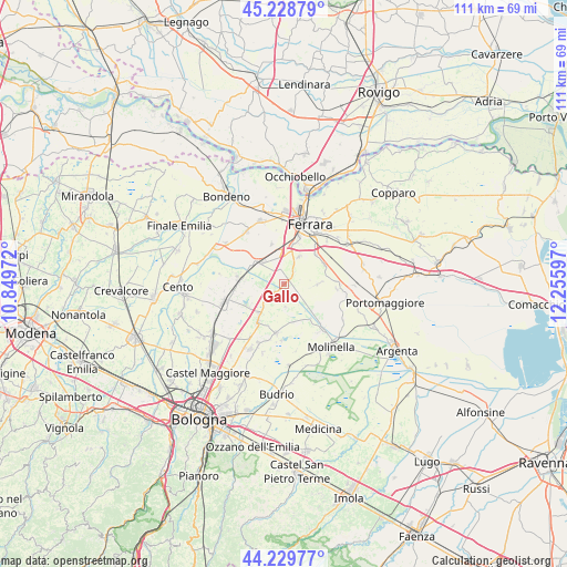
Gallo GPS coordinates[2]
44° 43' 53.184" North, 11° 33' 10.224" East
| Map corner | latitude | longitude |
|---|---|---|
| Upper-left | 45.22879°, | 10.84972° |
| Center: | 44.73144°, | 11.55284° |
| Lower-right: | 44.22977°, | 12.25597° |
| Map W x H: | 111.1×111.1 km | = 69×69mi |
| max Lat: | 47.04031° ⇑45.1% North |
| Gallo: | 44.73144° |
| min Lat: | ⇓54.9% South 35.50142° |
| min Long | Gallo | max Long |
| 6.69888° | 11.55284° | 18.48682° |
| W 50.1%⇐ | ⇒49.9% E |
Elevation
Elevation of Gallo is 11 m = 36 ft, and this is 295.7 m = 970 ft below average elevation for this country.
| Max E: |
2085 m = 6841 ft | 93.6% |
| Avg. | 306.7 m = 1006 ft | |
| Gallo | 11 m = 36 ft | |
Min E: |
-4 m = -13 ft | 6.4% |
See also: Italy elevation on elevation.city.
Geographical zone
Gallo is located in North temperate zone (between Tropic of Cancer and the Arctic Circle). Distance of this Northern Tropic circle is 2367.8 km =1471.3 mi to South.| Distance of | km | miles | from Gallo |
|---|---|---|---|
| North Pole | 5033.4 | 3127.6 | to North |
| Arctic Circle | 2427.5 | 1508.4 | to North |
| Tropic Cancer | 2367.8 | 1471.3 | to South |
| Equator | 4973.7 | 3090.5 | to South |


Nearby cities:
15 places around Gallo: (largest is in red/bold)
• Altedo
8.4 km =5.2 mi,  216°
216°
• Baricella
9.3 km =5.8 mi,  187°
187°
• Boschi
4.4 km =2.7 mi,  175°
175°
• Coronella
8.2 km =5.1 mi,  343°
343°
• Fossanova San Marco
8.9 km =5.5 mi,  42°
42°
• Gaibanella-Sant'Edigio
8.6 km =5.3 mi,  62°
62°
• Malalbergo
2.2 km =1.4 mi,  228°
228°
• Montalbano
3 km =1.9 mi, 37°
• Pegola
6.1 km =3.8 mi, 222°
• Poggio Renatico
6.5 km =4 mi,  306°
306°
• San Bartolomeo In Bosco
6.5 km =4 mi,  90°
90°
• San Gabriele-Mondonuovo
7.6 km =4.7 mi,  161°
161°
• San Martino
5.9 km =3.7 mi,  27°
27°
• San Venanzio
9.3 km =5.8 mi,  279°
279°
• San Vincenzo
9.2 km =5.7 mi, 275°
Sources, notices
• [Note1] Compared only with cities in Italy existing in our database
• [Src1] Map data: © OpenStreetMap contributors (CC-BY-SA)
• [Src2] Other city data from geonames.org with taken over terms of usage.
• [Src3] Geographical zone / Annual Mean Temperature by Robert A. Rohde @ Wikipedia
