Fusine geodata
Fusine (Lombardy) is a seat of a third-order administrative division; located in Italy in Europe/Rome (GMT+2) time zone. With population of 577 people, there are 9203 cities with bigger population in this country. Compared to other cities in Italy, 95% of cities are located further ↓South; 70.3% of cities are located further →East and 59.1% of cities have lower elevation than Fusine. Note1


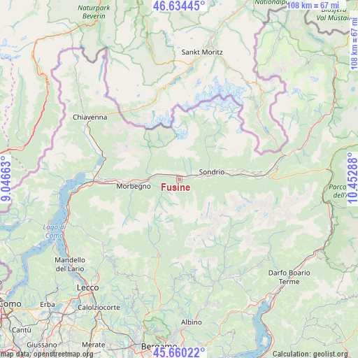
Fusine GPS coordinates[2]
46° 8' 58.164" North, 9° 44' 59.1" East
| Map corner | latitude | longitude |
|---|---|---|
| Upper-left | 46.63445°, | 9.04663° |
| Center: | 46.14949°, | 9.74975° |
| Lower-right: | 45.66022°, | 10.45288° |
| Map W x H: | 108.3×108.3 km | = 67.3×67.3mi |
| max Lat: | 47.04031° ⇑5% North |
| Fusine: | 46.14949° |
| min Lat: | ⇓95% South 35.50142° |
| min Long | Fusine | max Long |
| 6.69888° | 9.74975° | 18.48682° |
| W 29.7%⇐ | ⇒70.3% E |
Elevation
Elevation of Fusine is 293 m = 961 ft, and this is 13.7 m = 45 ft below average elevation for this country.
| Max E: |
2085 m = 6841 ft | 40.9% |
| Avg. | 306.7 m = 1006 ft | |
| Fusine | 293 m = 961 ft | |
Min E: |
-4 m = -13 ft | 59.1% |
See also: Italy elevation on elevation.city.
Geographical zone
Fusine is located in North temperate zone (between Tropic of Cancer and the Arctic Circle). Distance of this North polar circle is 2269.8 km =1410.4 mi to North.| Distance of | km | miles | from Fusine |
|---|---|---|---|
| North Pole | 4875.7 | 3029.6 | to North |
| Arctic Circle | 2269.8 | 1410.4 | to North |
| Tropic Cancer | 2525.4 | 1569.2 | to South |
| Equator | 5131.3 | 3188.4 | to South |


Nearby cities:
15 places around Fusine: (largest is in red/bold)
• Albosaggia
8 km =5 mi,  91°
91°
• Ardenno
8.1 km =5 mi,  283°
283°
• Berbenno di Valtellina
1.9 km =1.2 mi,  354°
354°
• Buglio in Monte
6.9 km =4.3 mi,  303°
303°
• Caiolo
5 km =3.1 mi, 89°
• Castione
4.7 km =2.9 mi,  56°
56°
• Castione Andevenno
4.7 km =2.9 mi, 56°
• Cedrasco
1.4 km =0.9 mi, 90°
• Colorina
1.6 km =1 mi,  286°
286°
• Forcola
7 km =4.3 mi, 278°
• Postalesio
3.4 km =2.1 mi,  37°
37°
• Sirta
6.9 km =4.3 mi, 278°
• Tartano
7.3 km =4.5 mi,  228°
228°
• Torchione-Moia
8.5 km =5.3 mi, 85°
• Villapinta
6.1 km =3.8 mi, 297°
Sources, notices
• [Note1] Compared only with cities in Italy existing in our database
• [Src1] Map data: © OpenStreetMap contributors (CC-BY-SA)
• [Src2] Other city data from geonames.org with taken over terms of usage.
• [Src3] Geographical zone / Annual Mean Temperature by Robert A. Rohde @ Wikipedia
