Fucecchio geodata
Fucecchio (Tuscany) is a seat of a third-order administrative division; located in Italy in Europe/Rome (GMT+2) time zone. With population of 14,479 people, there are 627 cities with bigger population in this country. Compared to other cities in Italy, 57.7% of cities are located further ↑North; 59.7% of cities are located further →East and 90.1% of cities have higher elevation than Fucecchio. Note1


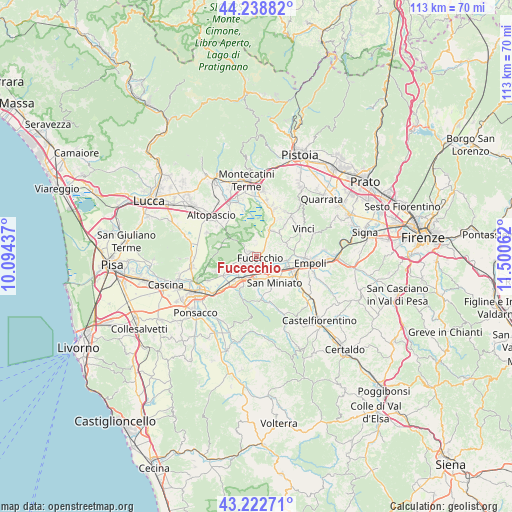
Fucecchio GPS coordinates[2]
43° 43' 58.512" North, 10° 47' 50.964" East
| Map corner | latitude | longitude |
|---|---|---|
| Upper-left | 44.23882°, | 10.09437° |
| Center: | 43.73292°, | 10.79749° |
| Lower-right: | 43.22271°, | 11.50062° |
| Map W x H: | 113×113 km | = 70.2×70.2mi |
| max Lat: | 47.04031° ⇑57.7% North |
| Fucecchio: | 43.73292° |
| min Lat: | ⇓42.3% South 35.50142° |
| min Long | Fucecchio | max Long |
| 6.69888° | 10.79749° | 18.48682° |
| W 40.3%⇐ | ⇒59.7% E |
Elevation
Elevation of Fucecchio is 18 m = 59 ft, and this is 288.7 m = 947 ft below average elevation for this country.
| Max E: |
2085 m = 6841 ft | 90.1% |
| Avg. | 306.7 m = 1006 ft | |
| Fucecchio | 18 m = 59 ft | |
Min E: |
-4 m = -13 ft | 9.9% |
See also: Italy elevation on elevation.city.
Geographical zone
Fucecchio is located in North temperate zone (between Tropic of Cancer and the Arctic Circle). Distance of this Northern Tropic circle is 2256.7 km =1402.2 mi to South.| Distance of | km | miles | from Fucecchio |
|---|---|---|---|
| North Pole | 5144.4 | 3196.6 | to North |
| Arctic Circle | 2538.5 | 1577.4 | to North |
| Tropic Cancer | 2256.7 | 1402.2 | to South |
| Equator | 4862.6 | 3021.5 | to South |


Nearby cities:
15 places around Fucecchio: (largest is in red/bold)
• Bassa
6.2 km =3.9 mi,  100°
100°
• Castelfranco di Sotto
5.2 km =3.2 mi,  231°
231°
• Cerreto Guidi
7.4 km =4.6 mi,  67°
67°
• Fornace-Torribina
5.8 km =3.6 mi,  59°
59°
• Isola
6.7 km =4.2 mi,  109°
109°
• Lazzeretto
7.5 km =4.7 mi,  42°
42°
• Le Botteghe
1.9 km =1.2 mi,  51°
51°
• Marcignana
7.2 km =4.5 mi, 103°
• San Donato
3.4 km =2.1 mi,  193°
193°
• San Miniato
7.3 km =4.5 mi,  144°
144°
• San Miniato Basso
5.6 km =3.5 mi, 141°
• San Pierino
2.5 km =1.6 mi,  147°
147°
• San Romano
5.4 km =3.4 mi,  205°
205°
• Santa Croce sull'Arno
2.7 km =1.7 mi, 228°
• Stabbia
6.3 km =3.9 mi,  28°
28°
Sources, notices
• [Note1] Compared only with cities in Italy existing in our database
• [Src1] Map data: © OpenStreetMap contributors (CC-BY-SA)
• [Src2] Other city data from geonames.org with taken over terms of usage.
• [Src3] Geographical zone / Annual Mean Temperature by Robert A. Rohde @ Wikipedia
