Isola geodata
Isola (Tuscany) is a populated place; located in Italy in Europe/Rome (GMT+2) time zone. With population of 639 people, there are 8711 cities with bigger population in this country. Compared to other cities in Italy, 58% of cities are located further ↑North; 58.8% of cities are located further →East and 86.7% of cities have higher elevation than Isola. Note1


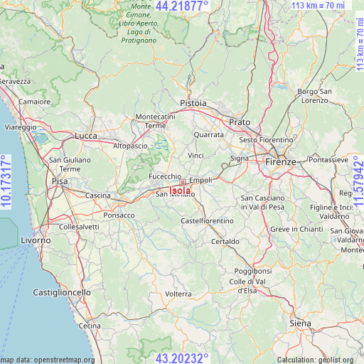
Isola GPS coordinates[2]
43° 42' 45.72" North, 10° 52' 34.644" East
| Map corner | latitude | longitude |
|---|---|---|
| Upper-left | 44.21877°, | 10.17317° |
| Center: | 43.7127°, | 10.87629° |
| Lower-right: | 43.20232°, | 11.57942° |
| Map W x H: | 113×113 km | = 70.2×70.2mi |
| max Lat: | 47.04031° ⇑58% North |
| Isola: | 43.7127° |
| min Lat: | ⇓42% South 35.50142° |
| min Long | Isola | max Long |
| 6.69888° | 10.87629° | 18.48682° |
| W 41.2%⇐ | ⇒58.8% E |
Elevation
Elevation of Isola is 26 m = 85 ft, and this is 280.7 m = 921 ft below average elevation for this country.
| Max E: |
2085 m = 6841 ft | 86.7% |
| Avg. | 306.7 m = 1006 ft | |
| Isola | 26 m = 85 ft | |
Min E: |
-4 m = -13 ft | 13.3% |
See also: Italy elevation on elevation.city.
Geographical zone
Isola is located in North temperate zone (between Tropic of Cancer and the Arctic Circle). Distance of this Northern Tropic circle is 2254.5 km =1400.9 mi to South.| Distance of | km | miles | from Isola |
|---|---|---|---|
| North Pole | 5146.7 | 3198 | to North |
| Arctic Circle | 2540.8 | 1578.8 | to North |
| Tropic Cancer | 2254.5 | 1400.9 | to South |
| Equator | 4860.4 | 3020.1 | to South |


Nearby cities:
15 places around Isola: (largest is in red/bold)
• Bassa
1.2 km =0.7 mi,  346°
346°
• Cerreto Guidi
5.1 km =3.2 mi,  5°
5°
• Empoli
5.8 km =3.6 mi,  84°
84°
• Fornace-Torribina
5.4 km =3.4 mi, 345°
• Fucecchio
6.7 km =4.2 mi,  289°
289°
• Le Botteghe
5.9 km =3.7 mi,  305°
305°
• Marcignana
0.9 km =0.6 mi,  46°
46°
• Monterappoli
6.5 km =4 mi,  124°
124°
• Ponte A Elsa
2.9 km =1.8 mi,  153°
153°
• Pozzale-Case Nuove
6.7 km =4.2 mi,  106°
106°
• San Donato
7.2 km =4.5 mi,  261°
261°
• San Miniato
4.3 km =2.7 mi,  210°
210°
• San Miniato Basso
3.6 km =2.2 mi,  232°
232°
• San Pierino
5 km =3.1 mi,  271°
271°
• Spicchio-Sovigliana
5.4 km =3.4 mi,  68°
68°
Sources, notices
• [Note1] Compared only with cities in Italy existing in our database
• [Src1] Map data: © OpenStreetMap contributors (CC-BY-SA)
• [Src2] Other city data from geonames.org with taken over terms of usage.
• [Src3] Geographical zone / Annual Mean Temperature by Robert A. Rohde @ Wikipedia
