Molazzana geodata
Molazzana (Tuscany) is a seat of a third-order administrative division; located in Italy in Europe/Rome (GMT+2) time zone. With population of 110 people, there are 11407 cities with bigger population in this country. Compared to other cities in Italy, 54% of cities are located further ↑North; 63.7% of cities are located further →East and 76.1% of cities have lower elevation than Molazzana. Note1


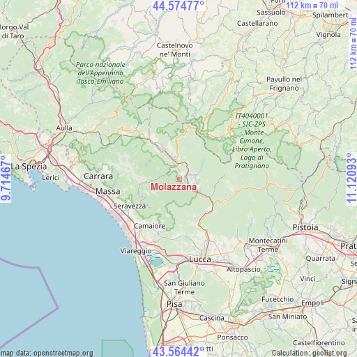
Molazzana GPS coordinates[2]
44° 4' 18.3" North, 10° 25' 4.08" East
| Map corner | latitude | longitude |
|---|---|---|
| Upper-left | 44.57477°, | 9.71467° |
| Center: | 44.07175°, | 10.4178° |
| Lower-right: | 43.56442°, | 11.12093° |
| Map W x H: | 112.3×112.3 km | = 69.8×69.8mi |
| max Lat: | 47.04031° ⇑54% North |
| Molazzana: | 44.07175° |
| min Lat: | ⇓46% South 35.50142° |
| min Long | Molazzana | max Long |
| 6.69888° | 10.4178° | 18.48682° |
| W 36.3%⇐ | ⇒63.7% E |
Elevation
Elevation of Molazzana is 467 m = 1532 ft, and this is 160.3 m = 526 ft above average elevation for this country.
| Max E: |
2085 m = 6841 ft | 23.9% |
| Molazzana | 467 m 1532 ft | |
| Avg. | 306.7 m = 1006 ft | |
Min E: |
-4 m = -13 ft | 76.1% |
See also: Italy elevation on elevation.city.
Geographical zone
Molazzana is located in North temperate zone (between Tropic of Cancer and the Arctic Circle). Distance of this Northern Tropic circle is 2294.4 km =1425.7 mi to South.| Distance of | km | miles | from Molazzana |
|---|---|---|---|
| North Pole | 5106.7 | 3173.2 | to North |
| Arctic Circle | 2500.9 | 1554 | to North |
| Tropic Cancer | 2294.4 | 1425.7 | to South |
| Equator | 4900.3 | 3044.9 | to South |


Nearby cities:
15 places around Molazzana: (largest is in red/bold)
• Barga
4.8 km =3 mi,  88°
88°
• Careggine
9.1 km =5.7 mi,  305°
305°
• Castelnuovo di Garfagnana
4.7 km =2.9 mi,  347°
347°
• Castelvecchio Pascoli
3.8 km =2.4 mi,  71°
71°
• Castiglione di Garfagnana
9 km =5.6 mi,  357°
357°
• Coreglia Antelminelli
8.6 km =5.3 mi,  96°
96°
• Fabbriche di Vallico
8.3 km =5.2 mi,  174°
174°
• Filecchio
6.6 km =4.1 mi,  110°
110°
• Fornaci di Barga
5 km =3.1 mi,  120°
120°
• Fosciandora
5.8 km =3.6 mi,  34°
34°
• Gallicano
2.4 km =1.5 mi,  127°
127°
• Piano di Coreglia-Ghivizzano
9 km =5.6 mi, 118°
• Pieve Fosciana
6.6 km =4.1 mi, 354°
• Ponte All'Ania
6.9 km =4.3 mi, 118°
• Villa Collemandina
9.8 km =6.1 mi, 350°
Sources, notices
• [Note1] Compared only with cities in Italy existing in our database
• [Src1] Map data: © OpenStreetMap contributors (CC-BY-SA)
• [Src2] Other city data from geonames.org with taken over terms of usage.
• [Src3] Geographical zone / Annual Mean Temperature by Robert A. Rohde @ Wikipedia
