Fontaniva geodata
Fontaniva (Veneto) is a seat of a third-order administrative division; located in Italy in Europe/Rome (GMT+2) time zone. With population of 6,081 people, there are 1619 cities with bigger population in this country. Compared to other cities in Italy, 78.5% of cities are located further ↓South; 52.5% of cities are located further ←West and 81.7% of cities have higher elevation than Fontaniva. Note1


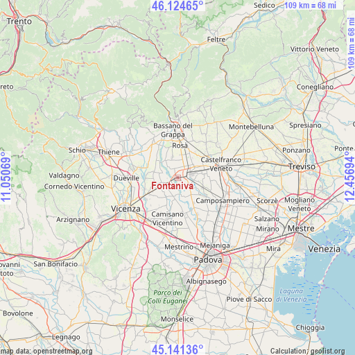
Fontaniva GPS coordinates[2]
45° 38' 6.576" North, 11° 45' 13.716" East
| Map corner | latitude | longitude |
|---|---|---|
| Upper-left | 46.12465°, | 11.05069° |
| Center: | 45.63516°, | 11.75381° |
| Lower-right: | 45.14136°, | 12.45694° |
| Map W x H: | 109.3×109.3 km | = 67.9×67.9mi |
| max Lat: | 47.04031° ⇑21.5% North |
| Fontaniva: | 45.63516° |
| min Lat: | ⇓78.5% South 35.50142° |
| min Long | Fontaniva | max Long |
| 6.69888° | 11.75381° | 18.48682° |
| W 52.5%⇐ | ⇒47.5% E |
Elevation
Elevation of Fontaniva is 43 m = 141 ft, and this is 263.7 m = 865 ft below average elevation for this country.
| Max E: |
2085 m = 6841 ft | 81.7% |
| Avg. | 306.7 m = 1006 ft | |
| Fontaniva | 43 m = 141 ft | |
Min E: |
-4 m = -13 ft | 18.3% |
See also: Italy elevation on elevation.city.
Geographical zone
Fontaniva is located in North temperate zone (between Tropic of Cancer and the Arctic Circle). Distance of this North polar circle is 2327 km =1445.9 mi to North.| Distance of | km | miles | from Fontaniva |
|---|---|---|---|
| North Pole | 4932.9 | 3065.2 | to North |
| Arctic Circle | 2327 | 1445.9 | to North |
| Tropic Cancer | 2468.2 | 1533.7 | to South |
| Equator | 5074.2 | 3153 | to South |


Nearby cities:
15 places around Fontaniva: (largest is in red/bold)
• Belvedere
6.3 km =3.9 mi,  12°
12°
• Ca' Onorai
5.4 km =3.4 mi,  41°
41°
• Camazzole
4.5 km =2.8 mi,  286°
286°
• Carmignano di Brenta
3.9 km =2.4 mi,  254°
254°
• Cittadella
2.6 km =1.6 mi,  64°
64°
• Galliera Veneta
6.4 km =4 mi, 55°
• Gazzo
6.9 km =4.3 mi,  211°
211°
• Grantorto
4 km =2.5 mi, 205°
• Pozzoleone
6.6 km =4.1 mi,  284°
284°
• San Giorgio in Bosco
6.6 km =4.1 mi,  141°
141°
• San Giorgio in Brenta
2.8 km =1.7 mi,  150°
150°
• San Pietro in Gu
6.9 km =4.3 mi,  244°
244°
• Santa Croce Bigolina
4.4 km =2.7 mi,  321°
321°
• Tezze
7.1 km =4.4 mi,  329°
329°
• Tombolo
5.5 km =3.4 mi,  85°
85°
Sources, notices
• [Note1] Compared only with cities in Italy existing in our database
• [Src1] Map data: © OpenStreetMap contributors (CC-BY-SA)
• [Src2] Other city data from geonames.org with taken over terms of usage.
• [Src3] Geographical zone / Annual Mean Temperature by Robert A. Rohde @ Wikipedia
