Tezze geodata
Tezze (Veneto) is a seat of a third-order administrative division; located in Italy in Europe/Rome (GMT+2) time zone. With population of 4,037 people, there are 2373 cities with bigger population in this country. Compared to other cities in Italy, 80.8% of cities are located further ↓South; 51.9% of cities are located further ←West and 75.4% of cities have higher elevation than Tezze. Note1


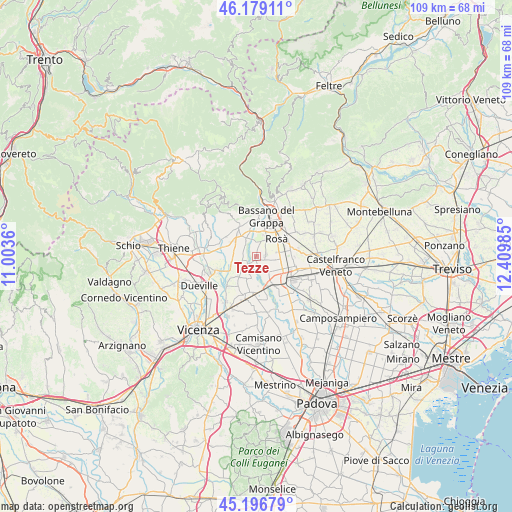
Tezze GPS coordinates[2]
45° 41' 24.396" North, 11° 42' 24.192" East
| Map corner | latitude | longitude |
|---|---|---|
| Upper-left | 46.17911°, | 11.0036° |
| Center: | 45.69011°, | 11.70672° |
| Lower-right: | 45.19679°, | 12.40985° |
| Map W x H: | 109.2×109.2 km | = 67.9×67.9mi |
| max Lat: | 47.04031° ⇑19.2% North |
| Tezze: | 45.69011° |
| min Lat: | ⇓80.8% South 35.50142° |
| min Long | Tezze | max Long |
| 6.69888° | 11.70672° | 18.48682° |
| W 51.9%⇐ | ⇒48.1% E |
Elevation
Elevation of Tezze is 72 m = 236 ft, and this is 234.7 m = 770 ft below average elevation for this country.
| Max E: |
2085 m = 6841 ft | 75.4% |
| Avg. | 306.7 m = 1006 ft | |
| Tezze | 72 m = 236 ft | |
Min E: |
-4 m = -13 ft | 24.6% |
See also: Italy elevation on elevation.city.
Geographical zone
Tezze is located in North temperate zone (between Tropic of Cancer and the Arctic Circle). Distance of this North polar circle is 2320.9 km =1442.1 mi to North.| Distance of | km | miles | from Tezze |
|---|---|---|---|
| North Pole | 4926.8 | 3061.4 | to North |
| Arctic Circle | 2320.9 | 1442.1 | to North |
| Tropic Cancer | 2474.3 | 1537.5 | to South |
| Equator | 5080.3 | 3156.8 | to South |


Nearby cities:
15 places around Tezze: (largest is in red/bold)
• Ancignano
6.7 km =4.2 mi,  241°
241°
• Belvedere
5.1 km =3.2 mi,  90°
90°
• Camazzole
4.9 km =3 mi,  187°
187°
• Carmignano di Brenta
7.2 km =4.5 mi,  180°
180°
• Cartigliano
2.7 km =1.7 mi,  341°
341°
• Fontaniva
7.1 km =4.4 mi,  149°
149°
• Friola
2.6 km =1.6 mi, 237°
• Longa
5.1 km =3.2 mi,  258°
258°
• Marostica
7 km =4.3 mi,  330°
330°
• Nove
4.1 km =2.5 mi, 327°
• Pozzoleone
5.3 km =3.3 mi,  211°
211°
• Rosà
4.4 km =2.7 mi,  72°
72°
• Santa Croce Bigolina
2.9 km =1.8 mi,  161°
161°
• Schiavon
4.8 km =3 mi,  278°
278°
• Villaraspa
7 km =4.3 mi,  296°
296°
Sources, notices
• [Note1] Compared only with cities in Italy existing in our database
• [Src1] Map data: © OpenStreetMap contributors (CC-BY-SA)
• [Src2] Other city data from geonames.org with taken over terms of usage.
• [Src3] Geographical zone / Annual Mean Temperature by Robert A. Rohde @ Wikipedia
