Fontanile geodata
Fontanile (Piedmont) is a seat of a third-order administrative division; located in Italy in Europe/Rome (GMT+2) time zone. With population of 369 people, there are 10397 cities with bigger population in this country. Compared to other cities in Italy, 55.3% of cities are located further ↓South; 88.8% of cities are located further →East and 56.6% of cities have lower elevation than Fontanile. Note1


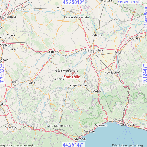
Fontanile GPS coordinates[2]
44° 45' 10.62" North, 8° 25' 16.824" East
| Map corner | latitude | longitude |
|---|---|---|
| Upper-left | 45.25012°, | 7.71822° |
| Center: | 44.75295°, | 8.42134° |
| Lower-right: | 44.25147°, | 9.12447° |
| Map W x H: | 111×111 km | = 69×69mi |
| max Lat: | 47.04031° ⇑44.7% North |
| Fontanile: | 44.75295° |
| min Lat: | ⇓55.3% South 35.50142° |
| min Long | Fontanile | max Long |
| 6.69888° | 8.42134° | 18.48682° |
| W 11.2%⇐ | ⇒88.8% E |
Elevation
Elevation of Fontanile is 276 m = 906 ft, and this is 30.7 m = 101 ft below average elevation for this country.
| Max E: |
2085 m = 6841 ft | 43.4% |
| Avg. | 306.7 m = 1006 ft | |
| Fontanile | 276 m = 906 ft | |
Min E: |
-4 m = -13 ft | 56.6% |
See also: Italy elevation on elevation.city.
Geographical zone
Fontanile is located in North temperate zone (between Tropic of Cancer and the Arctic Circle). Distance of this Northern Tropic circle is 2370.1 km =1472.7 mi to South.| Distance of | km | miles | from Fontanile |
|---|---|---|---|
| North Pole | 5031 | 3126.1 | to North |
| Arctic Circle | 2425.1 | 1506.9 | to North |
| Tropic Cancer | 2370.1 | 1472.7 | to South |
| Equator | 4976.1 | 3092 | to South |


Nearby cities:
15 places around Fontanile: (largest is in red/bold)
• Alice Bel Colle
3.8 km =2.4 mi,  142°
142°
• Bruno
4.6 km =2.9 mi,  18°
18°
• Calamandrana
6.9 km =4.3 mi,  255°
255°
• Castel Boglione
4.8 km =3 mi,  223°
223°
• Castel Rocchero
3.9 km =2.4 mi,  187°
187°
• Castelletto Molina
1 km =0.6 mi,  101°
101°
• Castelnuovo Belbo
5.4 km =3.4 mi,  352°
352°
• Ghiare-Madonna
7.1 km =4.4 mi,  328°
328°
• Incisa Scapaccino
7.1 km =4.4 mi, 329°
• Maranzana
4.6 km =2.9 mi,  79°
79°
• Mombaruzzo
3 km =1.9 mi,  45°
45°
• Montabone
6.5 km =4 mi,  201°
201°
• Nizza Monferrato
5.5 km =3.4 mi,  295°
295°
• Quaranti
2.2 km =1.4 mi, 95°
• Ricaldone
4.3 km =2.7 mi,  121°
121°
Sources, notices
• [Note1] Compared only with cities in Italy existing in our database
• [Src1] Map data: © OpenStreetMap contributors (CC-BY-SA)
• [Src2] Other city data from geonames.org with taken over terms of usage.
• [Src3] Geographical zone / Annual Mean Temperature by Robert A. Rohde @ Wikipedia
