Folgaria geodata
Folgaria (Trentino-Alto Adige) is a seat of a third-order administrative division; located in Italy in Europe/Rome (GMT+2) time zone. With population of 1,601 people, there are 4907 cities with bigger population in this country. Compared to other cities in Italy, 89.7% of cities are located further ↓South; 54.9% of cities are located further →East and 98.3% of cities have lower elevation than Folgaria. Note1
Administrative division(s):
- Level 1: Trentino-Alto Adige
- Level 2: Provincia autonoma di Trento
- Level 3: Folgaria


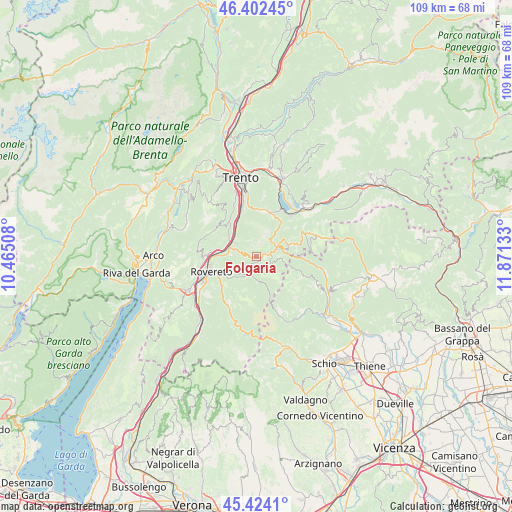
Folgaria GPS coordinates[2]
45° 54' 55.548" North, 11° 10' 5.52" East
| Map corner | latitude | longitude |
|---|---|---|
| Upper-left | 46.40245°, | 10.46508° |
| Center: | 45.91543°, | 11.1682° |
| Lower-right: | 45.4241°, | 11.87133° |
| Map W x H: | 108.8×108.8 km | = 67.6×67.6mi |
| max Lat: | 47.04031° ⇑10.3% North |
| Folgaria: | 45.91543° |
| min Lat: | ⇓89.7% South 35.50142° |
| min Long | Folgaria | max Long |
| 6.69888° | 11.1682° | 18.48682° |
| W 45.1%⇐ | ⇒54.9% E |
Elevation
Elevation of Folgaria is 1151 m = 3776 ft, and this is 844.3 m = 2770 ft above average elevation for this country.
| Max E: |
2085 m = 6841 ft | 1.7% |
| Folgaria | 1151 m 3776 ft | |
| Avg. | 306.7 m = 1006 ft | |
Min E: |
-4 m = -13 ft | 98.3% |
See also: Italy elevation on elevation.city.
Geographical zone
Folgaria is located in North temperate zone (between Tropic of Cancer and the Arctic Circle). Distance of this North polar circle is 2295.9 km =1426.6 mi to North.| Distance of | km | miles | from Folgaria |
|---|---|---|---|
| North Pole | 4901.7 | 3045.8 | to North |
| Arctic Circle | 2295.9 | 1426.6 | to North |
| Tropic Cancer | 2499.4 | 1553.1 | to South |
| Equator | 5105.3 | 3172.3 | to South |


Nearby cities:
15 places around Folgaria: (largest is in red/bold)
• Aldeno
9 km =5.6 mi,  319°
319°
• Besenello
5.5 km =3.4 mi,  304°
304°
• Calliano
6 km =3.7 mi,  289°
289°
• Centa San Nicolò
7.8 km =4.8 mi,  39°
39°
• Gionghi-Cappella
8.6 km =5.3 mi,  73°
73°
• Lastebasse
8.2 km =5.1 mi,  90°
90°
• Moscheri
9 km =5.6 mi,  234°
234°
• Nomi
7.6 km =4.7 mi,  281°
281°
• Piazza
4.3 km =2.7 mi,  190°
190°
• Pomarolo
9.8 km =6.1 mi, 278°
• Terragnolo
4.3 km =2.7 mi, 194°
• Trambileno
9 km =5.6 mi, 234°
• Vattaro
9.5 km =5.9 mi,  23°
23°
• Vigolo Vattaro
10.2 km =6.3 mi,  12°
12°
• Volano
8.1 km =5 mi,  271°
271°
Sources, notices
• [Note1] Compared only with cities in Italy existing in our database
• [Src1] Map data: © OpenStreetMap contributors (CC-BY-SA)
• [Src2] Other city data from geonames.org with taken over terms of usage.
• [Src3] Geographical zone / Annual Mean Temperature by Robert A. Rohde @ Wikipedia
