Terragnolo geodata
Terragnolo (Trentino-Alto Adige) is a seat of a third-order administrative division; located in Italy in Europe/Rome (GMT+2) time zone. With population of 749 people, there are 7963 cities with bigger population in this country. Compared to other cities in Italy, 88.5% of cities are located further ↓South; 55% of cities are located further →East and 92.6% of cities have lower elevation than Terragnolo. Note1
Administrative division(s):
- Level 1: Trentino-Alto Adige
- Level 2: Provincia autonoma di Trento
- Level 3: Terragnolo


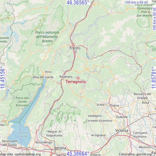
Terragnolo GPS coordinates[2]
45° 52' 41.88" North, 11° 9' 16.848" East
| Map corner | latitude | longitude |
|---|---|---|
| Upper-left | 46.36565°, | 10.45156° |
| Center: | 45.8783°, | 11.15468° |
| Lower-right: | 45.38664°, | 11.85781° |
| Map W x H: | 108.9×108.9 km | = 67.7×67.7mi |
| max Lat: | 47.04031° ⇑11.5% North |
| Terragnolo: | 45.8783° |
| min Lat: | ⇓88.5% South 35.50142° |
| min Long | Terragnolo | max Long |
| 6.69888° | 11.15468° | 18.48682° |
| W 45%⇐ | ⇒55% E |
Elevation
Elevation of Terragnolo is 788 m = 2585 ft, and this is 481.3 m = 1579 ft above average elevation for this country.
| Max E: |
2085 m = 6841 ft | 7.4% |
| Terragnolo | 788 m 2585 ft | |
| Avg. | 306.7 m = 1006 ft | |
Min E: |
-4 m = -13 ft | 92.6% |
See also: Italy elevation on elevation.city.
Geographical zone
Terragnolo is located in North temperate zone (between Tropic of Cancer and the Arctic Circle). Distance of this North polar circle is 2300 km =1429.2 mi to North.| Distance of | km | miles | from Terragnolo |
|---|---|---|---|
| North Pole | 4905.9 | 3048.4 | to North |
| Arctic Circle | 2300 | 1429.2 | to North |
| Tropic Cancer | 2495.3 | 1550.5 | to South |
| Equator | 5101.2 | 3169.7 | to South |


Nearby cities:
15 places around Terragnolo: (largest is in red/bold)
• Besenello
8.1 km =5 mi,  334°
334°
• Calliano
7.6 km =4.7 mi,  322°
322°
• Folgaria
4.3 km =2.7 mi,  14°
14°
• Laghi
10.9 km =6.8 mi,  123°
123°
• Lastebasse
10.1 km =6.3 mi,  66°
66°
• Moscheri
6.3 km =3.9 mi,  260°
260°
• Nogaredo
10.8 km =6.7 mi,  290°
290°
• Nomi
8.5 km =5.3 mi,  311°
311°
• Piazza
0.3 km =0.2 mi, 117°
• Pomarolo
10.3 km =6.4 mi,  302°
302°
• Rovereto
8.9 km =5.5 mi,  278°
278°
• Trambileno
6.4 km =4 mi, 260°
• Vallarsa
11 km =6.8 mi,  195°
195°
• Villa Lagarina
10.4 km =6.5 mi, 295°
• Volano
8.3 km =5.2 mi, 301°
Sources, notices
• [Note1] Compared only with cities in Italy existing in our database
• [Src1] Map data: © OpenStreetMap contributors (CC-BY-SA)
• [Src2] Other city data from geonames.org with taken over terms of usage.
• [Src3] Geographical zone / Annual Mean Temperature by Robert A. Rohde @ Wikipedia
