Firenzuola geodata
Firenzuola (Tuscany) is a seat of a third-order administrative division; located in Italy in Europe/Rome (GMT+2) time zone. With population of 1,765 people, there are 4547 cities with bigger population in this country. Compared to other cities in Italy, 53.5% of cities are located further ↑North; 52.1% of cities are located further →East and 73.1% of cities have lower elevation than Firenzuola. Note1


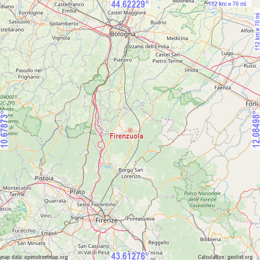
Firenzuola GPS coordinates[2]
44° 7' 10.848" North, 11° 22' 54.66" East
| Map corner | latitude | longitude |
|---|---|---|
| Upper-left | 44.62229°, | 10.67873° |
| Center: | 44.11968°, | 11.38185° |
| Lower-right: | 43.61276°, | 12.08498° |
| Map W x H: | 112.2×112.2 km | = 69.7×69.7mi |
| max Lat: | 47.04031° ⇑53.5% North |
| Firenzuola: | 44.11968° |
| min Lat: | ⇓46.5% South 35.50142° |
| min Long | Firenzuola | max Long |
| 6.69888° | 11.38185° | 18.48682° |
| W 47.9%⇐ | ⇒52.1% E |
Elevation
Elevation of Firenzuola is 426 m = 1398 ft, and this is 119.3 m = 391 ft above average elevation for this country.
| Max E: |
2085 m = 6841 ft | 26.9% |
| Firenzuola | 426 m 1398 ft | |
| Avg. | 306.7 m = 1006 ft | |
Min E: |
-4 m = -13 ft | 73.1% |
See also: Italy elevation on elevation.city.
Geographical zone
Firenzuola is located in North temperate zone (between Tropic of Cancer and the Arctic Circle). Distance of this Northern Tropic circle is 2299.7 km =1429 mi to South.| Distance of | km | miles | from Firenzuola |
|---|---|---|---|
| North Pole | 5101.4 | 3169.9 | to North |
| Arctic Circle | 2495.5 | 1550.6 | to North |
| Tropic Cancer | 2299.7 | 1429 | to South |
| Equator | 4905.6 | 3048.2 | to South |


Nearby cities:
15 places around Firenzuola: (largest is in red/bold)
• Baragazza
14.5 km =9 mi,  273°
273°
• Barberino di Mugello
17.7 km =11 mi,  220°
220°
• Castel del Rio
14.3 km =8.9 mi,  43°
43°
• Castiglione dei Pepoli
17.9 km =11.1 mi,  278°
278°
• Galliano
13.4 km =8.3 mi,  211°
211°
• Loiano
17 km =10.6 mi,  345°
345°
• Luco Mugello
13.3 km =8.3 mi,  175°
175°
• Monghidoro
12.4 km =7.7 mi,  337°
337°
• Palazzuolo sul Senio
12.9 km =8 mi,  93°
93°
• Panicaglia
15.1 km =9.4 mi,  172°
172°
• Piano del Voglio
14.3 km =8.9 mi,  291°
291°
• Ronta
13.5 km =8.4 mi,  163°
163°
• San Benedetto Val di Sambro
15.7 km =9.8 mi,  311°
311°
• Sant'Agata
12.1 km =7.5 mi,  198°
198°
• Scarperia
14.2 km =8.8 mi,  188°
188°
Sources, notices
• [Note1] Compared only with cities in Italy existing in our database
• [Src1] Map data: © OpenStreetMap contributors (CC-BY-SA)
• [Src2] Other city data from geonames.org with taken over terms of usage.
• [Src3] Geographical zone / Annual Mean Temperature by Robert A. Rohde @ Wikipedia
