Monghidoro geodata
Monghidoro (Emilia-Romagna) is a seat of a third-order administrative division; located in Italy in Europe/Rome (GMT+2) time zone. With population of 1,861 people, there are 4394 cities with bigger population in this country. Compared to other cities in Italy, 52.6% of cities are located further ↑North; 52.8% of cities are located further →East and 94.1% of cities have lower elevation than Monghidoro. Note1


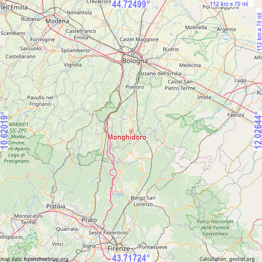
Monghidoro GPS coordinates[2]
44° 13' 23.772" North, 11° 19' 23.916" East
| Map corner | latitude | longitude |
|---|---|---|
| Upper-left | 44.72499°, | 10.62019° |
| Center: | 44.22327°, | 11.32331° |
| Lower-right: | 43.71724°, | 12.02644° |
| Map W x H: | 112.1×112.1 km | = 69.7×69.7mi |
| max Lat: | 47.04031° ⇑52.6% North |
| Monghidoro: | 44.22327° |
| min Lat: | ⇓47.4% South 35.50142° |
| min Long | Monghidoro | max Long |
| 6.69888° | 11.32331° | 18.48682° |
| W 47.2%⇐ | ⇒52.8% E |
Elevation
Elevation of Monghidoro is 840 m = 2756 ft, and this is 533.3 m = 1750 ft above average elevation for this country.
| Max E: |
2085 m = 6841 ft | 5.9% |
| Monghidoro | 840 m 2756 ft | |
| Avg. | 306.7 m = 1006 ft | |
Min E: |
-4 m = -13 ft | 94.1% |
See also: Italy elevation on elevation.city.
Geographical zone
Monghidoro is located in North temperate zone (between Tropic of Cancer and the Arctic Circle). Distance of this Northern Tropic circle is 2311.2 km =1436.1 mi to South.| Distance of | km | miles | from Monghidoro |
|---|---|---|---|
| North Pole | 5089.9 | 3162.7 | to North |
| Arctic Circle | 2484 | 1543.5 | to North |
| Tropic Cancer | 2311.2 | 1436.1 | to South |
| Equator | 4917.2 | 3055.4 | to South |


Nearby cities:
15 places around Monghidoro: (largest is in red/bold)
• Baragazza
14.4 km =8.9 mi,  222°
222°
• Castel del Rio
14.4 km =8.9 mi,  94°
94°
• Castiglione dei Pepoli
15.8 km =9.8 mi,  235°
235°
• Firenzuola
12.4 km =7.7 mi,  157°
157°
• Grizzana
13.9 km =8.6 mi,  286°
286°
• Grizzana Morandi
14.1 km =8.8 mi, 285°
• Lagaro
11.5 km =7.1 mi,  266°
266°
• Loiano
5 km =3.1 mi,  4°
4°
• Monterenzio
13.2 km =8.2 mi,  29°
29°
• Monzuno
7.6 km =4.7 mi,  323°
323°
• Piano del Voglio
10.6 km =6.6 mi,  234°
234°
• Rioveggio
11.4 km =7.1 mi,  299°
299°
• San Benedetto Val di Sambro
7.1 km =4.4 mi,  261°
261°
• Savazza
10.6 km =6.6 mi, 34°
• Vado
11.6 km =7.2 mi,  333°
333°
Sources, notices
• [Note1] Compared only with cities in Italy existing in our database
• [Src1] Map data: © OpenStreetMap contributors (CC-BY-SA)
• [Src2] Other city data from geonames.org with taken over terms of usage.
• [Src3] Geographical zone / Annual Mean Temperature by Robert A. Rohde @ Wikipedia
