Fagagna geodata
Fagagna (Friuli Venezia Giulia) is a seat of a third-order administrative division; located in Italy in Europe/Rome (GMT+2) time zone. With population of 4,942 people, there are 1972 cities with bigger population in this country. Compared to other cities in Italy, 94.2% of cities are located further ↓South; 69.4% of cities are located further ←West and 60.4% of cities have higher elevation than Fagagna. Note1
Administrative division(s):
- Level 1: Friuli Venezia Giulia
- Level 2: Provincia di Udine
- Level 3: Fagagna


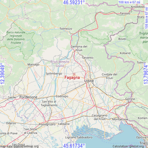
Fagagna GPS coordinates[2]
46° 6' 25.128" North, 13° 5' 36.996" East
| Map corner | latitude | longitude |
|---|---|---|
| Upper-left | 46.59231°, | 12.39049° |
| Center: | 46.10698°, | 13.09361° |
| Lower-right: | 45.61734°, | 13.79674° |
| Map W x H: | 108.4×108.4 km | = 67.4×67.4mi |
| max Lat: | 47.04031° ⇑5.8% North |
| Fagagna: | 46.10698° |
| min Lat: | ⇓94.2% South 35.50142° |
| min Long | Fagagna | max Long |
| 6.69888° | 13.09361° | 18.48682° |
| W 69.4%⇐ | ⇒30.6% E |
Elevation
Elevation of Fagagna is 160 m = 525 ft, and this is 146.7 m = 481 ft below average elevation for this country.
| Max E: |
2085 m = 6841 ft | 60.4% |
| Avg. | 306.7 m = 1006 ft | |
| Fagagna | 160 m = 525 ft | |
Min E: |
-4 m = -13 ft | 39.6% |
See also: Italy elevation on elevation.city.
Geographical zone
Fagagna is located in North temperate zone (between Tropic of Cancer and the Arctic Circle). Distance of this North polar circle is 2274.6 km =1413.4 mi to North.| Distance of | km | miles | from Fagagna |
|---|---|---|---|
| North Pole | 4880.4 | 3032.5 | to North |
| Arctic Circle | 2274.6 | 1413.4 | to North |
| Tropic Cancer | 2520.7 | 1566.3 | to South |
| Equator | 5126.6 | 3185.5 | to South |


Nearby cities:
15 places around Fagagna: (largest is in red/bold)
• Brazzacco
5.3 km =3.3 mi,  72°
72°
• Caporiacco
4.4 km =2.7 mi,  359°
359°
• Colloredo di Monte Albano
7.3 km =4.5 mi,  28°
28°
• Colloredo di Monte Albano-Lauzzana
6.2 km =3.9 mi,  21°
21°
• Coseano
5.8 km =3.6 mi,  258°
258°
• Madrisio
2.9 km =1.8 mi,  297°
297°
• Martignacco
3.9 km =2.4 mi,  113°
113°
• Moruzzo
2.7 km =1.7 mi,  58°
58°
• Nogaredo di Prato
4.7 km =2.9 mi,  137°
137°
• Pagnacco
7 km =4.3 mi,  83°
83°
• Plasencis
4.5 km =2.8 mi,  196°
196°
• Rive d'Arcano
5.2 km =3.2 mi, 295°
• Rodeano
6.4 km =4 mi,  273°
273°
• San Vito di Fagagna
2.8 km =1.7 mi,  230°
230°
• Silvella
4 km =2.5 mi,  237°
237°
Sources, notices
• [Note1] Compared only with cities in Italy existing in our database
• [Src1] Map data: © OpenStreetMap contributors (CC-BY-SA)
• [Src2] Other city data from geonames.org with taken over terms of usage.
• [Src3] Geographical zone / Annual Mean Temperature by Robert A. Rohde @ Wikipedia
