Plasencis geodata
Plasencis (Friuli Venezia Giulia) is a populated place; located in Italy in Europe/Rome (GMT+2) time zone. With population of 586 people, there are 9123 cities with bigger population in this country. Compared to other cities in Italy, 93.4% of cities are located further ↓South; 69.2% of cities are located further ←West and 68.3% of cities have higher elevation than Plasencis. Note1
Administrative division(s):
- Level 1: Friuli Venezia Giulia
- Level 2: Provincia di Udine
- Level 3: Mereto di Tomba


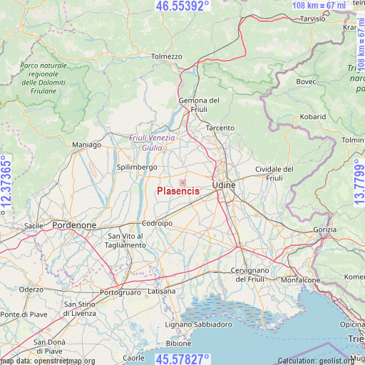
Plasencis GPS coordinates[2]
46° 4' 5.7" North, 13° 4' 36.372" East
| Map corner | latitude | longitude |
|---|---|---|
| Upper-left | 46.55392°, | 12.37365° |
| Center: | 46.06825°, | 13.07677° |
| Lower-right: | 45.57827°, | 13.7799° |
| Map W x H: | 108.5×108.5 km | = 67.4×67.4mi |
| max Lat: | 47.04031° ⇑6.6% North |
| Plasencis: | 46.06825° |
| min Lat: | ⇓93.4% South 35.50142° |
| min Long | Plasencis | max Long |
| 6.69888° | 13.07677° | 18.48682° |
| W 69.2%⇐ | ⇒30.8% E |
Elevation
Elevation of Plasencis is 107 m = 351 ft, and this is 199.7 m = 655 ft below average elevation for this country.
| Max E: |
2085 m = 6841 ft | 68.3% |
| Avg. | 306.7 m = 1006 ft | |
| Plasencis | 107 m = 351 ft | |
Min E: |
-4 m = -13 ft | 31.7% |
See also: Italy elevation on elevation.city.
Geographical zone
Plasencis is located in North temperate zone (between Tropic of Cancer and the Arctic Circle). Distance of this North polar circle is 2278.9 km =1416 mi to North.| Distance of | km | miles | from Plasencis |
|---|---|---|---|
| North Pole | 4884.8 | 3035.3 | to North |
| Arctic Circle | 2278.9 | 1416 | to North |
| Tropic Cancer | 2516.4 | 1563.6 | to South |
| Equator | 5122.3 | 3182.8 | to South |


Nearby cities:
15 places around Plasencis: (largest is in red/bold)
• Basiliano
6 km =3.7 mi,  184°
184°
• Basiliano-Vissandone
5.2 km =3.2 mi,  166°
166°
• Blessano
3.8 km =2.4 mi,  146°
146°
• Colloredo di Prato
5.5 km =3.4 mi,  110°
110°
• Coseano
5.4 km =3.4 mi,  305°
305°
• Fagagna
4.5 km =2.8 mi,  16°
16°
• Madrisio
5.8 km =3.6 mi,  346°
346°
• Martignacco
5.6 km =3.5 mi,  60°
60°
• Mereto di Tomba
3.1 km =1.9 mi,  232°
232°
• Nogaredo di Prato
4.5 km =2.8 mi,  79°
79°
• Pantianicco
5.9 km =3.7 mi,  212°
212°
• San Vito di Fagagna
2.7 km =1.7 mi,  341°
341°
• Silvella
3 km =1.9 mi,  315°
315°
• Variano
5.4 km =3.4 mi, 148°
• Villaorba
6.5 km =4 mi, 184°
Sources, notices
• [Note1] Compared only with cities in Italy existing in our database
• [Src1] Map data: © OpenStreetMap contributors (CC-BY-SA)
• [Src2] Other city data from geonames.org with taken over terms of usage.
• [Src3] Geographical zone / Annual Mean Temperature by Robert A. Rohde @ Wikipedia
