Cozzana geodata
Cozzana (Apulia) is a populated place; located in Italy in Europe/Rome (GMT+2) time zone. With population of 1,435 people, there are 5278 cities with bigger population in this country. Compared to other cities in Italy, 79.6% of cities are located further ↑North; 98.3% of cities are located further ←West and 52.2% of cities have higher elevation than Cozzana. Note1


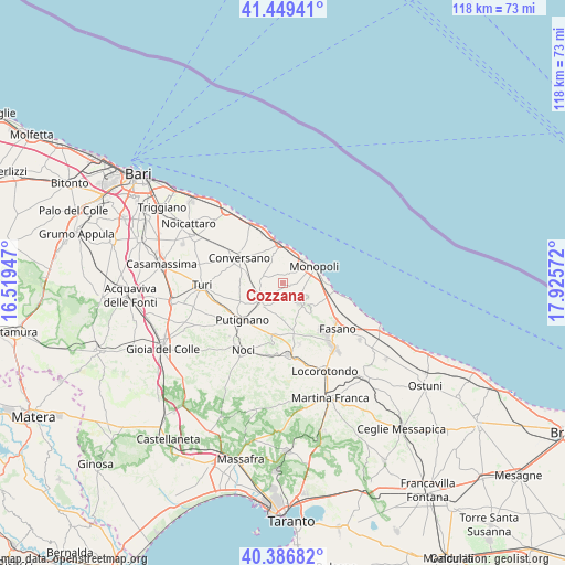
Cozzana GPS coordinates[2]
40° 55' 12.9" North, 17° 13' 21.324" East
| Map corner | latitude | longitude |
|---|---|---|
| Upper-left | 41.44941°, | 16.51947° |
| Center: | 40.92025°, | 17.22259° |
| Lower-right: | 40.38682°, | 17.92572° |
| Map W x H: | 118.1×118.1 km | = 73.4×73.4mi |
| max Lat: | 47.04031° ⇑79.6% North |
| Cozzana: | 40.92025° |
| min Lat: | ⇓20.4% South 35.50142° |
| min Long | Cozzana | max Long |
| 6.69888° | 17.22259° | 18.48682° |
| W 98.3%⇐ | ⇒1.7% E |
Elevation
Elevation of Cozzana is 221 m = 725 ft, and this is 85.7 m = 281 ft below average elevation for this country.
| Max E: |
2085 m = 6841 ft | 52.2% |
| Avg. | 306.7 m = 1006 ft | |
| Cozzana | 221 m = 725 ft | |
Min E: |
-4 m = -13 ft | 47.8% |
See also: Italy elevation on elevation.city.
Geographical zone
Cozzana is located in North temperate zone (between Tropic of Cancer and the Arctic Circle). Distance of this Northern Tropic circle is 1944 km =1207.9 mi to South.| Distance of | km | miles | from Cozzana |
|---|---|---|---|
| North Pole | 5457.2 | 3390.9 | to North |
| Arctic Circle | 2851.3 | 1771.7 | to North |
| Tropic Cancer | 1944 | 1207.9 | to South |
| Equator | 4549.9 | 2827.2 | to South |


Nearby cities:
15 places around Cozzana: (largest is in red/bold)
• Alcanterini
6.3 km =3.9 mi,  215°
215°
• Antonelli
2.9 km =1.8 mi,  159°
159°
• Castellana
6.1 km =3.8 mi,  231°
231°
• Conversano
10.6 km =6.6 mi,  300°
300°
• Coreggia
13.1 km =8.1 mi, 164°
• Gorgofreddo
5.1 km =3.2 mi,  138°
138°
• Impalata
7.4 km =4.6 mi, 138°
• Lamie di Olimpie-Selva
14.8 km =9.2 mi, 140°
• Monopoli
7 km =4.3 mi,  62°
62°
• Polignano a Mare
8 km =5 mi,  359°
359°
• Putignano
11.4 km =7.1 mi, 227°
• San Pietro Piturno
13 km =8.1 mi,  243°
243°
• Sant'Antonio d'Ascula
10.7 km =6.6 mi,  113°
113°
• Santa Lucia
10.1 km =6.3 mi,  145°
145°
• Triggianello
4.6 km =2.9 mi,  276°
276°
Sources, notices
• [Note1] Compared only with cities in Italy existing in our database
• [Src1] Map data: © OpenStreetMap contributors (CC-BY-SA)
• [Src2] Other city data from geonames.org with taken over terms of usage.
• [Src3] Geographical zone / Annual Mean Temperature by Robert A. Rohde @ Wikipedia
