Impalata geodata
Impalata (Apulia) is a populated place; located in Italy in Europe/Rome (GMT+2) time zone. With population of 631 people, there are 8769 cities with bigger population in this country. Compared to other cities in Italy, 80.5% of cities are located further ↑North; 98.4% of cities are located further ←West and 65.2% of cities have lower elevation than Impalata. Note1


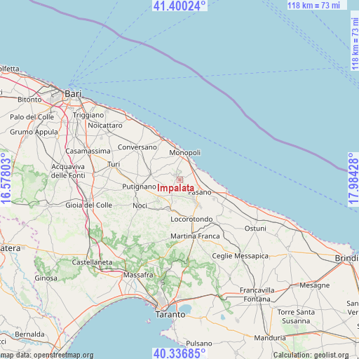
Impalata GPS coordinates[2]
40° 52' 14.448" North, 17° 16' 52.14" East
| Map corner | latitude | longitude |
|---|---|---|
| Upper-left | 41.40024°, | 16.57803° |
| Center: | 40.87068°, | 17.28115° |
| Lower-right: | 40.33685°, | 17.98428° |
| Map W x H: | 118.2×118.2 km | = 73.4×73.4mi |
| max Lat: | 47.04031° ⇑80.5% North |
| Impalata: | 40.87068° |
| min Lat: | ⇓19.5% South 35.50142° |
| min Long | Impalata | max Long |
| 6.69888° | 17.28115° | 18.48682° |
| W 98.4%⇐ | ⇒1.6% E |
Elevation
Elevation of Impalata is 345 m = 1132 ft, and this is 38.3 m = 126 ft above average elevation for this country.
| Max E: |
2085 m = 6841 ft | 34.8% |
| Impalata | 345 m 1132 ft | |
| Avg. | 306.7 m = 1006 ft | |
Min E: |
-4 m = -13 ft | 65.2% |
See also: Italy elevation on elevation.city.
Geographical zone
Impalata is located in North temperate zone (between Tropic of Cancer and the Arctic Circle). Distance of this Northern Tropic circle is 1938.5 km =1204.5 mi to South.| Distance of | km | miles | from Impalata |
|---|---|---|---|
| North Pole | 5462.7 | 3394.4 | to North |
| Arctic Circle | 2856.8 | 1775.1 | to North |
| Tropic Cancer | 1938.5 | 1204.5 | to South |
| Equator | 4544.4 | 2823.8 | to South |


Nearby cities:
15 places around Impalata: (largest is in red/bold)
• Alberobello
10.3 km =6.4 mi,  201°
201°
• Alcanterini
8.6 km =5.3 mi,  272°
272°
• Antonelli
4.8 km =3 mi,  305°
305°
• Castellana
9.9 km =6.2 mi,  280°
280°
• Coreggia
7.3 km =4.5 mi,  191°
191°
• Cozzana
7.4 km =4.6 mi,  318°
318°
• Fasano
7.7 km =4.8 mi,  119°
119°
• Gorgofreddo
2.2 km =1.4 mi, 318°
• Lamie di Olimpie-Selva
7.5 km =4.7 mi,  142°
142°
• Monopoli
8.8 km =5.5 mi,  8°
8°
• Sant'Antonio d'Ascula
5 km =3.1 mi,  75°
75°
• Santa Lucia
2.9 km =1.8 mi,  163°
163°
• Savelletri
10.7 km =6.6 mi,  87°
87°
• Stazione di Fasano
8.9 km =5.5 mi,  107°
107°
• Triggianello
11.2 km =7 mi,  302°
302°
Sources, notices
• [Note1] Compared only with cities in Italy existing in our database
• [Src1] Map data: © OpenStreetMap contributors (CC-BY-SA)
• [Src2] Other city data from geonames.org with taken over terms of usage.
• [Src3] Geographical zone / Annual Mean Temperature by Robert A. Rohde @ Wikipedia
