Cortanze geodata
Cortanze (Piedmont) is a seat of a third-order administrative division; located in Italy in Europe/Rome (GMT+2) time zone. With population of 257 people, there are 10860 cities with bigger population in this country. Compared to other cities in Italy, 60.3% of cities are located further ↓South; 92.5% of cities are located further →East and 56% of cities have lower elevation than Cortanze. Note1


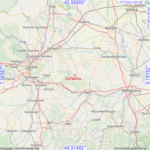
Cortanze GPS coordinates[2]
45° 0' 50.544" North, 8° 5' 19.644" East
| Map corner | latitude | longitude |
|---|---|---|
| Upper-left | 45.50895°, | 7.38567° |
| Center: | 45.01404°, | 8.08879° |
| Lower-right: | 44.51482°, | 8.79192° |
| Map W x H: | 110.5×110.5 km | = 68.7×68.7mi |
| max Lat: | 47.04031° ⇑39.7% North |
| Cortanze: | 45.01404° |
| min Lat: | ⇓60.3% South 35.50142° |
| min Long | Cortanze | max Long |
| 6.69888° | 8.08879° | 18.48682° |
| W 7.5%⇐ | ⇒92.5% E |
Elevation
Elevation of Cortanze is 272 m = 892 ft, and this is 34.7 m = 114 ft below average elevation for this country.
| Max E: |
2085 m = 6841 ft | 44% |
| Avg. | 306.7 m = 1006 ft | |
| Cortanze | 272 m = 892 ft | |
Min E: |
-4 m = -13 ft | 56% |
See also: Italy elevation on elevation.city.
Geographical zone
Cortanze is located in North temperate zone (between Tropic of Cancer and the Arctic Circle). Distance of this North polar circle is 2396.1 km =1488.9 mi to North.| Distance of | km | miles | from Cortanze |
|---|---|---|---|
| North Pole | 5002 | 3108.1 | to North |
| Arctic Circle | 2396.1 | 1488.9 | to North |
| Tropic Cancer | 2399.2 | 1490.8 | to South |
| Equator | 5005.1 | 3110 | to South |


Nearby cities:
15 places around Cortanze: (largest is in red/bold)
• Camerano
2.5 km =1.6 mi,  178°
178°
• Camerano Casasco
2.5 km =1.6 mi, 175°
• Chiusano d'Asti
3.8 km =2.4 mi,  142°
142°
• Cinaglio
4.4 km =2.7 mi,  168°
168°
• Corsione
4.7 km =2.9 mi,  108°
108°
• Cortazzone
4.4 km =2.7 mi,  209°
209°
• Cossombrato
4.8 km =3 mi,  124°
124°
• Cunico
3 km =1.9 mi,  10°
10°
• Montechiaro d'Asti
2 km =1.2 mi, 112°
• Montiglio
5.7 km =3.5 mi, 7°
• Piea
2 km =1.2 mi,  316°
316°
• Piovà Massaia
5.5 km =3.4 mi,  326°
326°
• Soglio
2.1 km =1.3 mi,  202°
202°
• Viale
3.4 km =2.1 mi,  243°
243°
• Villa San Secondo
3.7 km =2.3 mi, 105°
Sources, notices
• [Note1] Compared only with cities in Italy existing in our database
• [Src1] Map data: © OpenStreetMap contributors (CC-BY-SA)
• [Src2] Other city data from geonames.org with taken over terms of usage.
• [Src3] Geographical zone / Annual Mean Temperature by Robert A. Rohde @ Wikipedia
