Cinaglio geodata
Cinaglio (Piedmont) is a seat of a third-order administrative division; located in Italy in Europe/Rome (GMT+2) time zone. With population of 290 people, there are 10710 cities with bigger population in this country. Compared to other cities in Italy, 59.4% of cities are located further ↓South; 92.3% of cities are located further →East and 53.2% of cities have lower elevation than Cinaglio. Note1


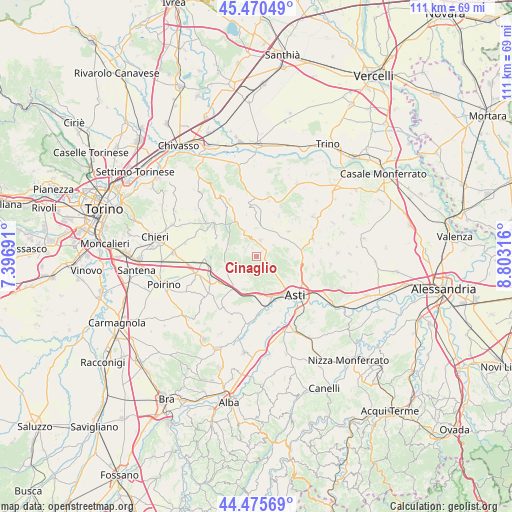
Cinaglio GPS coordinates[2]
44° 58' 30.9" North, 8° 6' 0.108" East
| Map corner | latitude | longitude |
|---|---|---|
| Upper-left | 45.47049°, | 7.39691° |
| Center: | 44.97525°, | 8.10003° |
| Lower-right: | 44.47569°, | 8.80316° |
| Map W x H: | 110.6×110.6 km | = 68.7×68.7mi |
| max Lat: | 47.04031° ⇑40.6% North |
| Cinaglio: | 44.97525° |
| min Lat: | ⇓59.4% South 35.50142° |
| min Long | Cinaglio | max Long |
| 6.69888° | 8.10003° | 18.48682° |
| W 7.7%⇐ | ⇒92.3% E |
Elevation
Elevation of Cinaglio is 254 m = 833 ft, and this is 52.7 m = 173 ft below average elevation for this country.
| Max E: |
2085 m = 6841 ft | 46.8% |
| Avg. | 306.7 m = 1006 ft | |
| Cinaglio | 254 m = 833 ft | |
Min E: |
-4 m = -13 ft | 53.2% |
See also: Italy elevation on elevation.city.
Geographical zone
Cinaglio is located in North temperate zone (between Tropic of Cancer and the Arctic Circle). Distance of this Northern Tropic circle is 2394.9 km =1488.1 mi to South.| Distance of | km | miles | from Cinaglio |
|---|---|---|---|
| North Pole | 5006.3 | 3110.8 | to North |
| Arctic Circle | 2400.4 | 1491.5 | to North |
| Tropic Cancer | 2394.9 | 1488.1 | to South |
| Equator | 5000.8 | 3107.4 | to South |


Nearby cities:
15 places around Cinaglio: (largest is in red/bold)
• Camerano
2 km =1.2 mi,  335°
335°
• Camerano Casasco
2 km =1.2 mi, 338°
• Castellero
5.9 km =3.7 mi,  200°
200°
• Chiusano d'Asti
1.9 km =1.2 mi,  48°
48°
• Corsione
4.6 km =2.9 mi, 51°
• Cortandone
3.7 km =2.3 mi,  241°
241°
• Cortanze
4.4 km =2.7 mi,  348°
348°
• Cortazzone
3.1 km =1.9 mi,  278°
278°
• Cossombrato
3.5 km =2.2 mi,  62°
62°
• Monale
4.7 km =2.9 mi,  207°
207°
• Montechiaro d'Asti
3.7 km =2.3 mi,  15°
15°
• Settime
1.9 km =1.2 mi,  143°
143°
• Soglio
2.9 km =1.8 mi,  323°
323°
• Viale
4.8 km =3 mi,  305°
305°
• Villa San Secondo
4.3 km =2.7 mi,  39°
39°
Sources, notices
• [Note1] Compared only with cities in Italy existing in our database
• [Src1] Map data: © OpenStreetMap contributors (CC-BY-SA)
• [Src2] Other city data from geonames.org with taken over terms of usage.
• [Src3] Geographical zone / Annual Mean Temperature by Robert A. Rohde @ Wikipedia
