Corchiano geodata
Corchiano (Latium) is a seat of a third-order administrative division; located in Italy in Europe/Rome (GMT+2) time zone. With population of 2,861 people, there are 3155 cities with bigger population in this country. Compared to other cities in Italy, 67.3% of cities are located further ↑North; 60.8% of cities are located further ←West and 54.7% of cities have higher elevation than Corchiano. Note1


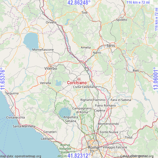
Corchiano GPS coordinates[2]
42° 20' 41.82" North, 12° 21' 24.768" East
| Map corner | latitude | longitude |
|---|---|---|
| Upper-left | 42.86248°, | 11.65376° |
| Center: | 42.34495°, | 12.35688° |
| Lower-right: | 41.82312°, | 13.06001° |
| Map W x H: | 115.6×115.6 km | = 71.8×71.8mi |
| max Lat: | 47.04031° ⇑67.3% North |
| Corchiano: | 42.34495° |
| min Lat: | ⇓32.7% South 35.50142° |
| min Long | Corchiano | max Long |
| 6.69888° | 12.35688° | 18.48682° |
| W 60.8%⇐ | ⇒39.2% E |
Elevation
Elevation of Corchiano is 204 m = 669 ft, and this is 102.7 m = 337 ft below average elevation for this country.
| Max E: |
2085 m = 6841 ft | 54.7% |
| Avg. | 306.7 m = 1006 ft | |
| Corchiano | 204 m = 669 ft | |
Min E: |
-4 m = -13 ft | 45.3% |
See also: Italy elevation on elevation.city.
Geographical zone
Corchiano is located in North temperate zone (between Tropic of Cancer and the Arctic Circle). Distance of this Northern Tropic circle is 2102.4 km =1306.4 mi to South.| Distance of | km | miles | from Corchiano |
|---|---|---|---|
| North Pole | 5298.7 | 3292.5 | to North |
| Arctic Circle | 2692.9 | 1673.3 | to North |
| Tropic Cancer | 2102.4 | 1306.4 | to South |
| Equator | 4708.3 | 2925.6 | to South |


Nearby cities:
15 places around Corchiano: (largest is in red/bold)
• Caprarola
10 km =6.2 mi,  255°
255°
• Carbognano
7.8 km =4.8 mi, 257°
• Castel Sant'Elia
10.5 km =6.5 mi,  173°
173°
• Civita Castellana
7.2 km =4.5 mi,  143°
143°
• Fabrica di Roma
4.9 km =3 mi, 256°
• Faleri
4.3 km =2.7 mi,  183°
183°
• Gallese
4.6 km =2.9 mi,  45°
45°
• Magliano Sabina
10.8 km =6.7 mi,  77°
77°
• Orte Scalo
10.8 km =6.7 mi,  22°
22°
• Regolelli
5.8 km =3.6 mi, 184°
• Sassacci
7.3 km =4.5 mi,  109°
109°
• Scalo Teverina
7.9 km =4.9 mi,  64°
64°
• Vallerano
8.9 km =5.5 mi,  298°
298°
• Vasanello
7.8 km =4.8 mi,  354°
354°
• Vignanello
7.5 km =4.7 mi, 300°
Sources, notices
• [Note1] Compared only with cities in Italy existing in our database
• [Src1] Map data: © OpenStreetMap contributors (CC-BY-SA)
• [Src2] Other city data from geonames.org with taken over terms of usage.
• [Src3] Geographical zone / Annual Mean Temperature by Robert A. Rohde @ Wikipedia
