Carbognano geodata
Carbognano (Latium) is a seat of a third-order administrative division; located in Italy in Europe/Rome (GMT+2) time zone. With population of 1,932 people, there are 4270 cities with bigger population in this country. Compared to other cities in Italy, 67.4% of cities are located further ↑North; 59.4% of cities are located further ←West and 70.2% of cities have lower elevation than Carbognano. Note1


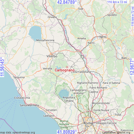
Carbognano GPS coordinates[2]
42° 19' 48.864" North, 12° 15' 52.452" East
| Map corner | latitude | longitude |
|---|---|---|
| Upper-left | 42.84789°, | 11.56145° |
| Center: | 42.33024°, | 12.26457° |
| Lower-right: | 41.80829°, | 12.9677° |
| Map W x H: | 115.6×115.6 km | = 71.8×71.8mi |
| max Lat: | 47.04031° ⇑67.4% North |
| Carbognano: | 42.33024° |
| min Lat: | ⇓32.6% South 35.50142° |
| min Long | Carbognano | max Long |
| 6.69888° | 12.26457° | 18.48682° |
| W 59.4%⇐ | ⇒40.6% E |
Elevation
Elevation of Carbognano is 396 m = 1299 ft, and this is 89.3 m = 293 ft above average elevation for this country.
| Max E: |
2085 m = 6841 ft | 29.8% |
| Carbognano | 396 m 1299 ft | |
| Avg. | 306.7 m = 1006 ft | |
Min E: |
-4 m = -13 ft | 70.2% |
See also: Italy elevation on elevation.city.
Geographical zone
Carbognano is located in North temperate zone (between Tropic of Cancer and the Arctic Circle). Distance of this Northern Tropic circle is 2100.8 km =1305.4 mi to South.| Distance of | km | miles | from Carbognano |
|---|---|---|---|
| North Pole | 5300.4 | 3293.5 | to North |
| Arctic Circle | 2694.5 | 1674.3 | to North |
| Tropic Cancer | 2100.8 | 1305.4 | to South |
| Equator | 4706.7 | 2924.6 | to South |


Nearby cities:
15 places around Carbognano: (largest is in red/bold)
• Canepina
6.5 km =4 mi,  335°
335°
• Capranica
11 km =6.8 mi,  223°
223°
• Caprarola
2.3 km =1.4 mi,  249°
249°
• Colle Diana
8.9 km =5.5 mi,  208°
208°
• Corchiano
7.8 km =4.8 mi,  77°
77°
• Fabrica di Roma
2.8 km =1.7 mi, 80°
• Faleri
7.8 km =4.8 mi,  109°
109°
• Nepi
11.7 km =7.3 mi,  146°
146°
• Regolelli
8.2 km =5.1 mi,  120°
120°
• Ronciglione
6.1 km =3.8 mi, 221°
• Soriano nel Cimino
10.1 km =6.3 mi,  345°
345°
• Sutri
10.2 km =6.3 mi,  202°
202°
• Vallerano
5.9 km =3.7 mi,  357°
357°
• Vasanello
11.6 km =7.2 mi,  35°
35°
• Vignanello
5.5 km =3.4 mi,  11°
11°
Sources, notices
• [Note1] Compared only with cities in Italy existing in our database
• [Src1] Map data: © OpenStreetMap contributors (CC-BY-SA)
• [Src2] Other city data from geonames.org with taken over terms of usage.
• [Src3] Geographical zone / Annual Mean Temperature by Robert A. Rohde @ Wikipedia
