Cintano geodata
Cintano (Piedmont) is a seat of a third-order administrative division; located in Italy in Europe/Rome (GMT+2) time zone. With population of 122 people, there are 11373 cities with bigger population in this country. Compared to other cities in Italy, 71.2% of cities are located further ↓South; 96.4% of cities are located further →East and 86.9% of cities have lower elevation than Cintano. Note1


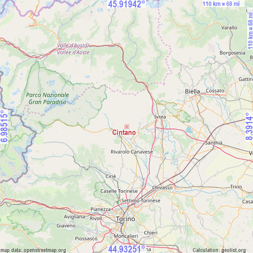
Cintano GPS coordinates[2]
45° 25' 41.232" North, 7° 41' 17.772" East
| Map corner | latitude | longitude |
|---|---|---|
| Upper-left | 45.91942°, | 6.98515° |
| Center: | 45.42812°, | 7.68827° |
| Lower-right: | 44.93251°, | 8.3914° |
| Map W x H: | 109.7×109.7 km | = 68.2×68.2mi |
| max Lat: | 47.04031° ⇑28.8% North |
| Cintano: | 45.42812° |
| min Lat: | ⇓71.2% South 35.50142° |
| min Long | Cintano | max Long |
| 6.69888° | 7.68827° | 18.48682° |
| W 3.6%⇐ | ⇒96.4% E |
Elevation
Elevation of Cintano is 649 m = 2129 ft, and this is 342.3 m = 1123 ft above average elevation for this country.
| Max E: |
2085 m = 6841 ft | 13.1% |
| Cintano | 649 m 2129 ft | |
| Avg. | 306.7 m = 1006 ft | |
Min E: |
-4 m = -13 ft | 86.9% |
See also: Italy elevation on elevation.city.
Geographical zone
Cintano is located in North temperate zone (between Tropic of Cancer and the Arctic Circle). Distance of this North polar circle is 2350 km =1460.2 mi to North.| Distance of | km | miles | from Cintano |
|---|---|---|---|
| North Pole | 4955.9 | 3079.5 | to North |
| Arctic Circle | 2350 | 1460.2 | to North |
| Tropic Cancer | 2445.2 | 1519.4 | to South |
| Equator | 5051.1 | 3138.6 | to South |


Nearby cities:
15 places around Cintano: (largest is in red/bold)
• Baldissero Canavese
4.8 km =3 mi,  114°
114°
• Borgiallo
1.9 km =1.2 mi,  230°
230°
• Castellamonte
5.3 km =3.3 mi,  162°
162°
• Castelnuovo Nigra
1.2 km =0.7 mi,  23°
23°
• Chiesanuova
2.8 km =1.7 mi,  245°
245°
• Colleretto Castelnuovo
0.9 km =0.6 mi, 225°
• Cuorgnè
4.9 km =3 mi,  217°
217°
• Frassinetto
6.3 km =3.9 mi,  280°
280°
• Issiglio
5.5 km =3.4 mi,  68°
68°
• Rueglio
6.8 km =4.2 mi,  49°
49°
• Strambinello
6.4 km =4 mi,  95°
95°
• Torre Canavese
6.9 km =4.3 mi,  125°
125°
• Valperga
6.8 km =4.2 mi,  198°
198°
• Vidracco
5.4 km =3.4 mi,  87°
87°
• Vistrorio
6.4 km =4 mi,  76°
76°
Sources, notices
• [Note1] Compared only with cities in Italy existing in our database
• [Src1] Map data: © OpenStreetMap contributors (CC-BY-SA)
• [Src2] Other city data from geonames.org with taken over terms of usage.
• [Src3] Geographical zone / Annual Mean Temperature by Robert A. Rohde @ Wikipedia
