Chiuppano geodata
Chiuppano (Veneto) is a seat of a third-order administrative division; located in Italy in Europe/Rome (GMT+2) time zone. With population of 2,504 people, there are 3517 cities with bigger population in this country. Compared to other cities in Italy, 84.1% of cities are located further ↓South; 51.1% of cities are located further →East and 51.7% of cities have lower elevation than Chiuppano. Note1


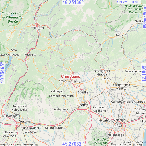
Chiuppano GPS coordinates[2]
45° 45' 46.8" North, 11° 27' 27.972" East
| Map corner | latitude | longitude |
|---|---|---|
| Upper-left | 46.25136°, | 10.75465° |
| Center: | 45.763°, | 11.45777° |
| Lower-right: | 45.27032°, | 12.1609° |
| Map W x H: | 109.1×109.1 km | = 67.8×67.8mi |
| max Lat: | 47.04031° ⇑15.9% North |
| Chiuppano: | 45.763° |
| min Lat: | ⇓84.1% South 35.50142° |
| min Long | Chiuppano | max Long |
| 6.69888° | 11.45777° | 18.48682° |
| W 48.9%⇐ | ⇒51.1% E |
Elevation
Elevation of Chiuppano is 245 m = 804 ft, and this is 61.7 m = 202 ft below average elevation for this country.
| Max E: |
2085 m = 6841 ft | 48.3% |
| Avg. | 306.7 m = 1006 ft | |
| Chiuppano | 245 m = 804 ft | |
Min E: |
-4 m = -13 ft | 51.7% |
See also: Italy elevation on elevation.city.
Geographical zone
Chiuppano is located in North temperate zone (between Tropic of Cancer and the Arctic Circle). Distance of this North polar circle is 2312.8 km =1437.1 mi to North.| Distance of | km | miles | from Chiuppano |
|---|---|---|---|
| North Pole | 4918.7 | 3056.3 | to North |
| Arctic Circle | 2312.8 | 1437.1 | to North |
| Tropic Cancer | 2482.4 | 1542.5 | to South |
| Equator | 5088.4 | 3161.8 | to South |


Nearby cities:
15 places around Chiuppano: (largest is in red/bold)
• Caltrano
1.2 km =0.7 mi,  352°
352°
• Calvene
4.2 km =2.6 mi,  85°
85°
• Carrè
1.6 km =1 mi,  179°
179°
• Centrale
4.3 km =2.7 mi,  156°
156°
• Cogollo del Cengio
3.4 km =2.1 mi,  312°
312°
• Fara Vicentino
7.1 km =4.4 mi,  107°
107°
• Grumolo Pedemonte
5.1 km =3.2 mi,  148°
148°
• Lugo di Vicenza
5.8 km =3.6 mi, 109°
• Piovene Rocchette
2.1 km =1.3 mi,  248°
248°
• Santorso
6.3 km =3.9 mi,  239°
239°
• Thiene
6.3 km =3.9 mi, 164°
• Velo d'Astico
7.5 km =4.7 mi,  292°
292°
• Zanè
4.6 km =2.9 mi,  188°
188°
• Zona Industriale
6.5 km =4 mi,  218°
218°
• Zugliano
6.3 km =3.9 mi,  125°
125°
Sources, notices
• [Note1] Compared only with cities in Italy existing in our database
• [Src1] Map data: © OpenStreetMap contributors (CC-BY-SA)
• [Src2] Other city data from geonames.org with taken over terms of usage.
• [Src3] Geographical zone / Annual Mean Temperature by Robert A. Rohde @ Wikipedia
