Thiene geodata
Thiene (Veneto) is a seat of a third-order administrative division; located in Italy in Europe/Rome (GMT+2) time zone. With population of 21,145 people, there are 416 cities with bigger population in this country. Compared to other cities in Italy, 81.6% of cities are located further ↓South; 50.9% of cities are located further →East and 61.6% of cities have higher elevation than Thiene. Note1


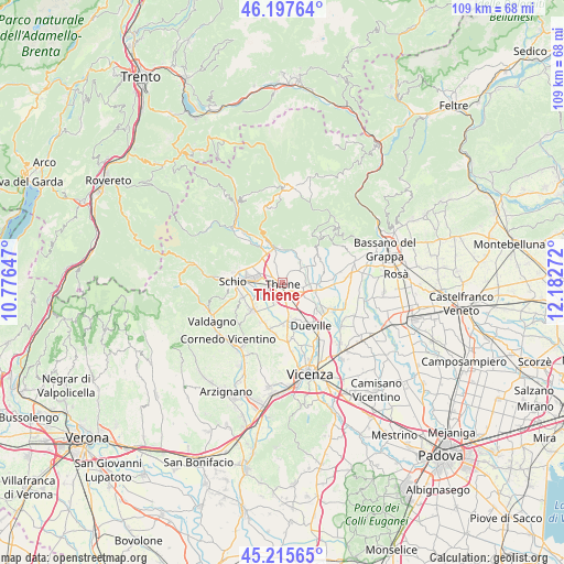
Thiene GPS coordinates[2]
45° 42' 31.68" North, 11° 28' 46.524" East
| Map corner | latitude | longitude |
|---|---|---|
| Upper-left | 46.19764°, | 10.77647° |
| Center: | 45.7088°, | 11.47959° |
| Lower-right: | 45.21565°, | 12.18272° |
| Map W x H: | 109.2×109.2 km | = 67.9×67.9mi |
| max Lat: | 47.04031° ⇑18.4% North |
| Thiene: | 45.7088° |
| min Lat: | ⇓81.6% South 35.50142° |
| min Long | Thiene | max Long |
| 6.69888° | 11.47959° | 18.48682° |
| W 49.1%⇐ | ⇒50.9% E |
Elevation
Elevation of Thiene is 151 m = 495 ft, and this is 155.7 m = 511 ft below average elevation for this country.
| Max E: |
2085 m = 6841 ft | 61.6% |
| Avg. | 306.7 m = 1006 ft | |
| Thiene | 151 m = 495 ft | |
Min E: |
-4 m = -13 ft | 38.4% |
See also: Italy elevation on elevation.city.
Geographical zone
Thiene is located in North temperate zone (between Tropic of Cancer and the Arctic Circle). Distance of this North polar circle is 2318.8 km =1440.8 mi to North.| Distance of | km | miles | from Thiene |
|---|---|---|---|
| North Pole | 4924.7 | 3060.1 | to North |
| Arctic Circle | 2318.8 | 1440.8 | to North |
| Tropic Cancer | 2476.4 | 1538.8 | to South |
| Equator | 5082.3 | 3158 | to South |


Nearby cities:
15 places around Thiene: (largest is in red/bold)
• Breganze
6.3 km =3.9 mi,  93°
93°
• Carrè
4.8 km =3 mi,  339°
339°
• Centrale
2.1 km =1.3 mi,  1°
1°
• Giavenale
6.3 km =3.9 mi,  261°
261°
• Grumolo Pedemonte
2 km =1.2 mi,  29°
29°
• Levà
6.3 km =3.9 mi,  139°
139°
• Lugo di Vicenza
5.6 km =3.5 mi,  43°
43°
• Marano Vicentino
3.9 km =2.4 mi,  248°
248°
• Preara-Moraro-Levà Nord
5.9 km =3.7 mi,  123°
123°
• Rozzampia
3.7 km =2.3 mi,  151°
151°
• Santo
3.9 km =2.4 mi,  171°
171°
• Sarcedo
4 km =2.5 mi,  102°
102°
• Zanè
2.8 km =1.7 mi,  301°
301°
• Zona Industriale
5.8 km =3.6 mi,  279°
279°
• Zugliano
4.2 km =2.6 mi,  55°
55°
Sources, notices
• [Note1] Compared only with cities in Italy existing in our database
• [Src1] Map data: © OpenStreetMap contributors (CC-BY-SA)
• [Src2] Other city data from geonames.org with taken over terms of usage.
• [Src3] Geographical zone / Annual Mean Temperature by Robert A. Rohde @ Wikipedia
