Chions geodata
Chions (Friuli Venezia Giulia) is a populated place; located in Italy in Europe/Rome (GMT+2) time zone. With population of 1,679 people, there are 4712 cities with bigger population in this country. Compared to other cities in Italy, 87.5% of cities are located further ↓South; 65.1% of cities are located further ←West and 93.6% of cities have higher elevation than Chions. Note1
Administrative division(s):
- Level 1: Friuli Venezia Giulia
- Level 2: Provincia di Pordenone
- Level 3: Chions


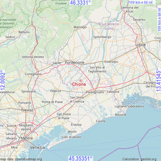
Chions GPS coordinates[2]
45° 50' 43.656" North, 12° 42' 44.352" East
| Map corner | latitude | longitude |
|---|---|---|
| Upper-left | 46.3331°, | 12.0092° |
| Center: | 45.84546°, | 12.71232° |
| Lower-right: | 45.35351°, | 13.41545° |
| Map W x H: | 108.9×108.9 km | = 67.7×67.7mi |
| max Lat: | 47.04031° ⇑12.5% North |
| Chions: | 45.84546° |
| min Lat: | ⇓87.5% South 35.50142° |
| min Long | Chions | max Long |
| 6.69888° | 12.71232° | 18.48682° |
| W 65.1%⇐ | ⇒34.9% E |
Elevation
Elevation of Chions is 11 m = 36 ft, and this is 295.7 m = 970 ft below average elevation for this country.
| Max E: |
2085 m = 6841 ft | 93.6% |
| Avg. | 306.7 m = 1006 ft | |
| Chions | 11 m = 36 ft | |
Min E: |
-4 m = -13 ft | 6.4% |
See also: Italy elevation on elevation.city.
Geographical zone
Chions is located in North temperate zone (between Tropic of Cancer and the Arctic Circle). Distance of this North polar circle is 2303.6 km =1431.4 mi to North.| Distance of | km | miles | from Chions |
|---|---|---|---|
| North Pole | 4909.5 | 3050.6 | to North |
| Arctic Circle | 2303.6 | 1431.4 | to North |
| Tropic Cancer | 2491.6 | 1548.2 | to South |
| Equator | 5097.5 | 3167.4 | to South |


Nearby cities:
15 places around Chions: (largest is in red/bold)
• Annone Veneto
6.5 km =4 mi,  197°
197°
• Barco
4.3 km =2.7 mi,  226°
226°
• Belfiore
7 km =4.3 mi,  170°
170°
• Cecchini
7.3 km =4.5 mi,  287°
287°
• Cinto Caomaggiore
5.7 km =3.5 mi,  110°
110°
• Fagnigola
2.4 km =1.5 mi, 294°
• Frattina
5.1 km =3.2 mi,  211°
211°
• Meduna di Livenza
7.2 km =4.5 mi,  244°
244°
• Pasiano
6.6 km =4.1 mi,  274°
274°
• Pozzo
7.8 km =4.8 mi, 274°
• Pramaggiore
4 km =2.5 mi,  148°
148°
• Pramaggiore Blessaglia
4.6 km =2.9 mi, 167°
• Pravisdomini
3.2 km =2 mi, 205°
• Sesto al Reghena
7.8 km =4.8 mi,  86°
86°
• Villotta
3.8 km =2.4 mi,  58°
58°
Sources, notices
• [Note1] Compared only with cities in Italy existing in our database
• [Src1] Map data: © OpenStreetMap contributors (CC-BY-SA)
• [Src2] Other city data from geonames.org with taken over terms of usage.
• [Src3] Geographical zone / Annual Mean Temperature by Robert A. Rohde @ Wikipedia
