Chioggia geodata
Chioggia (Veneto) is a seat of a third-order administrative division; located in Italy in Europe/Rome (GMT+2) time zone. With population of 41,897 people, there are 168 cities with bigger population in this country. Compared to other cities in Italy, 65.4% of cities are located further ↓South; 59.5% of cities are located further ←West and 97.2% of cities have higher elevation than Chioggia. Note1


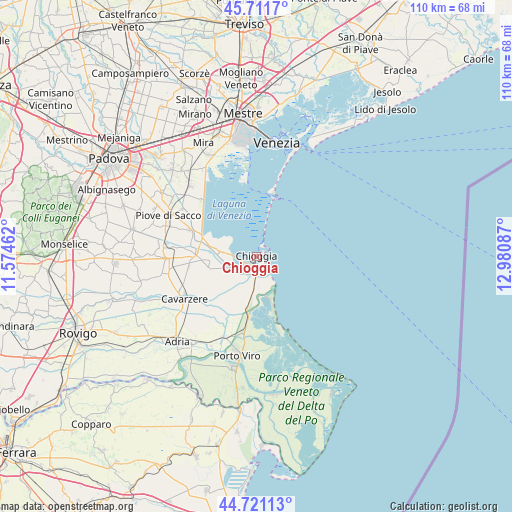
Chioggia GPS coordinates[2]
45° 13' 6.852" North, 12° 16' 39.864" East
| Map corner | latitude | longitude |
|---|---|---|
| Upper-left | 45.7117°, | 11.57462° |
| Center: | 45.21857°, | 12.27774° |
| Lower-right: | 44.72113°, | 12.98087° |
| Map W x H: | 110.1×110.1 km | = 68.4×68.4mi |
| max Lat: | 47.04031° ⇑34.6% North |
| Chioggia: | 45.21857° |
| min Lat: | ⇓65.4% South 35.50142° |
| min Long | Chioggia | max Long |
| 6.69888° | 12.27774° | 18.48682° |
| W 59.5%⇐ | ⇒40.5% E |
Elevation
Elevation of Chioggia is 5 m = 16 ft, and this is 301.7 m = 990 ft below average elevation for this country.
| Max E: |
2085 m = 6841 ft | 97.2% |
| Avg. | 306.7 m = 1006 ft | |
| Chioggia | 5 m = 16 ft | |
Min E: |
-4 m = -13 ft | 2.8% |
See also: Chioggia elevation on elevation.city.
Geographical zone
Chioggia is located in North temperate zone (between Tropic of Cancer and the Arctic Circle). Distance of this North polar circle is 2373.3 km =1474.7 mi to North.| Distance of | km | miles | from Chioggia |
|---|---|---|---|
| North Pole | 4979.2 | 3093.9 | to North |
| Arctic Circle | 2373.3 | 1474.7 | to North |
| Tropic Cancer | 2421.9 | 1504.9 | to South |
| Equator | 5027.8 | 3124.1 | to South |


Nearby cities:
15 places around Chioggia: (largest is in red/bold)
• Alberoni
14.7 km =9.1 mi,  12°
12°
• Boscochiaro
15.2 km =9.4 mi,  233°
233°
• Ca' Lino
6.6 km =4.1 mi,  165°
165°
• Cambroso
17 km =10.6 mi,  296°
296°
• Civé
10.1 km =6.3 mi,  263°
263°
• Codevigo
14.9 km =9.3 mi,  290°
290°
• Conche
8.7 km =5.4 mi,  283°
283°
• Correzzola
16.6 km =10.3 mi, 276°
• Pellestrina
6.8 km =4.2 mi,  16°
16°
• Rosolina
16.2 km =10.1 mi,  193°
193°
• San Pietro in Volta
11.2 km =7 mi, 15°
• Sant'Anna
5.8 km =3.6 mi,  183°
183°
• Valli
6.9 km =4.3 mi,  274°
274°
• Vallonga
16.7 km =10.4 mi, 291°
• Villaggio Busonera
16.3 km =10.1 mi,  240°
240°
Sources, notices
• [Note1] Compared only with cities in Italy existing in our database
• [Src1] Map data: © OpenStreetMap contributors (CC-BY-SA)
• [Src2] Other city data from geonames.org with taken over terms of usage.
• [Src3] Geographical zone / Annual Mean Temperature by Robert A. Rohde @ Wikipedia
