Vallonga geodata
Vallonga (Veneto) is a populated place; located in Italy in Europe/Rome (GMT+2) time zone. With population of 1,298 people, there are 5640 cities with bigger population in this country. Compared to other cities in Italy, 66.7% of cities are located further ↓South; 57% of cities are located further ←West and 98.4% of cities have higher elevation than Vallonga. Note1


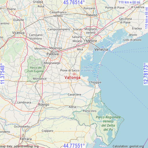
Vallonga GPS coordinates[2]
45° 16' 20.928" North, 12° 4' 42.96" East
| Map corner | latitude | longitude |
|---|---|---|
| Upper-left | 45.76514°, | 11.37548° |
| Center: | 45.27248°, | 12.0786° |
| Lower-right: | 44.77551°, | 12.78173° |
| Map W x H: | 110×110 km | = 68.4×68.4mi |
| max Lat: | 47.04031° ⇑33.3% North |
| Vallonga: | 45.27248° |
| min Lat: | ⇓66.7% South 35.50142° |
| min Long | Vallonga | max Long |
| 6.69888° | 12.0786° | 18.48682° |
| W 57%⇐ | ⇒43% E |
Elevation
Elevation of Vallonga is 3 m = 10 ft, and this is 303.7 m = 996 ft below average elevation for this country.
| Max E: |
2085 m = 6841 ft | 98.4% |
| Avg. | 306.7 m = 1006 ft | |
| Vallonga | 3 m = 10 ft | |
Min E: |
-4 m = -13 ft | 1.6% |
See also: Italy elevation on elevation.city.
Geographical zone
Vallonga is located in North temperate zone (between Tropic of Cancer and the Arctic Circle). Distance of this North polar circle is 2367.3 km =1471 mi to North.| Distance of | km | miles | from Vallonga |
|---|---|---|---|
| North Pole | 4973.2 | 3090.2 | to North |
| Arctic Circle | 2367.3 | 1471 | to North |
| Tropic Cancer | 2427.9 | 1508.6 | to South |
| Equator | 5033.8 | 3127.9 | to South |


Nearby cities:
15 places around Vallonga: (largest is in red/bold)
• Arzerello
4.2 km =2.6 mi,  272°
272°
• Arzergrande
2.4 km =1.5 mi, 270°
• Bojon-Lova
7.5 km =4.7 mi,  2°
2°
• Brugine
7.3 km =4.5 mi,  291°
291°
• Cambroso
1.7 km =1.1 mi,  13°
13°
• Campagnola
6.3 km =3.9 mi,  276°
276°
• Campolongo Maggiore
6.3 km =3.9 mi,  334°
334°
• Codevigo
1.8 km =1.1 mi,  112°
112°
• Correzzola
4.2 km =2.6 mi,  192°
192°
• Corte
4 km =2.5 mi,  352°
352°
• Lova
7.2 km =4.5 mi,  31°
31°
• Piove di Sacco-Piovega
4.2 km =2.6 mi,  309°
309°
• Pontelongo
5.1 km =3.2 mi,  234°
234°
• Sant'Angelo di Piove di Sacco
7.4 km =4.6 mi, 312°
• Villa del Bosco
7.3 km =4.5 mi,  210°
210°
Sources, notices
• [Note1] Compared only with cities in Italy existing in our database
• [Src1] Map data: © OpenStreetMap contributors (CC-BY-SA)
• [Src2] Other city data from geonames.org with taken over terms of usage.
• [Src3] Geographical zone / Annual Mean Temperature by Robert A. Rohde @ Wikipedia
