Cerasolo geodata
Cerasolo (Emilia-Romagna) is a populated place; located in Italy in Europe/Rome (GMT+2) time zone. With population of 1,309 people, there are 5607 cities with bigger population in this country. Compared to other cities in Italy, 54.8% of cities are located further ↑North; 62.7% of cities are located further ←West and 78.5% of cities have higher elevation than Cerasolo. Note1


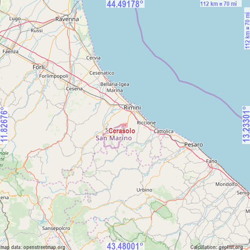
Cerasolo GPS coordinates[2]
43° 59' 16.98" North, 12° 31' 47.568" East
| Map corner | latitude | longitude |
|---|---|---|
| Upper-left | 44.49178°, | 11.82676° |
| Center: | 43.98805°, | 12.52988° |
| Lower-right: | 43.48001°, | 13.23301° |
| Map W x H: | 112.5×112.5 km | = 69.9×69.9mi |
| max Lat: | 47.04031° ⇑54.8% North |
| Cerasolo: | 43.98805° |
| min Lat: | ⇓45.2% South 35.50142° |
| min Long | Cerasolo | max Long |
| 6.69888° | 12.52988° | 18.48682° |
| W 62.7%⇐ | ⇒37.3% E |
Elevation
Elevation of Cerasolo is 57 m = 187 ft, and this is 249.7 m = 819 ft below average elevation for this country.
| Max E: |
2085 m = 6841 ft | 78.5% |
| Avg. | 306.7 m = 1006 ft | |
| Cerasolo | 57 m = 187 ft | |
Min E: |
-4 m = -13 ft | 21.5% |
See also: Italy elevation on elevation.city.
Geographical zone
Cerasolo is located in North temperate zone (between Tropic of Cancer and the Arctic Circle). Distance of this Northern Tropic circle is 2285.1 km =1419.9 mi to South.| Distance of | km | miles | from Cerasolo |
|---|---|---|---|
| North Pole | 5116 | 3178.9 | to North |
| Arctic Circle | 2510.2 | 1559.8 | to North |
| Tropic Cancer | 2285.1 | 1419.9 | to South |
| Equator | 4891 | 3039.1 | to South |


Nearby cities:
15 places around Cerasolo: (largest is in red/bold)
• Ca' Acquabuona
6 km =3.7 mi,  46°
46°
• Case del Molino
6.2 km =3.9 mi,  86°
86°
• Coriano
6 km =3.7 mi,  110°
110°
• Corpolò
7.1 km =4.4 mi,  299°
299°
• Croce
8.6 km =5.3 mi,  146°
146°
• Gaiofana
3.6 km =2.2 mi,  58°
58°
• Monte Colombo
7.8 km =4.8 mi,  166°
166°
• Montescudo
7.9 km =4.9 mi, 173°
• Ospedaletto
3.3 km =2.1 mi,  98°
98°
• Rimini
8.2 km =5.1 mi,  20°
20°
• San Martino dei Mulini
7.2 km =4.5 mi,  312°
312°
• San Savino
7.6 km =4.7 mi,  135°
135°
• Sant'Andrea in Besanigo
7.3 km =4.5 mi, 94°
• Trarivi
5.8 km =3.6 mi, 168°
• Villa Verucchio
7.8 km =4.8 mi,  284°
284°
Sources, notices
• [Note1] Compared only with cities in Italy existing in our database
• [Src1] Map data: © OpenStreetMap contributors (CC-BY-SA)
• [Src2] Other city data from geonames.org with taken over terms of usage.
• [Src3] Geographical zone / Annual Mean Temperature by Robert A. Rohde @ Wikipedia
