Gaiofana geodata
Gaiofana (Emilia-Romagna) is a populated place; located in Italy in Europe/Rome (GMT+2) time zone. With population of 743 people, there are 7998 cities with bigger population in this country. Compared to other cities in Italy, 54.6% of cities are located further ↑North; 63.2% of cities are located further ←West and 86.1% of cities have higher elevation than Gaiofana. Note1


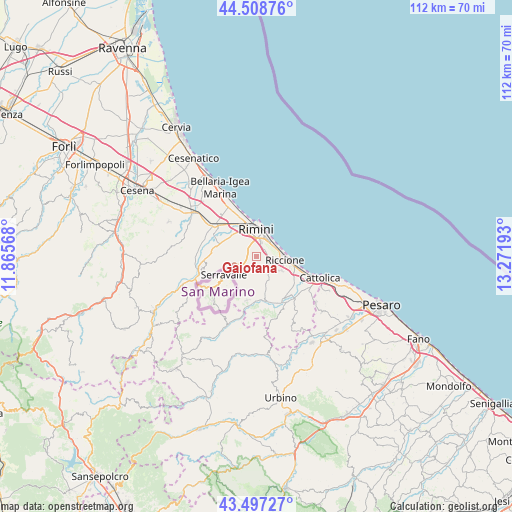
Gaiofana GPS coordinates[2]
44° 0' 18.612" North, 12° 34' 7.68" East
| Map corner | latitude | longitude |
|---|---|---|
| Upper-left | 44.50876°, | 11.86568° |
| Center: | 44.00517°, | 12.5688° |
| Lower-right: | 43.49727°, | 13.27193° |
| Map W x H: | 112.5×112.5 km | = 69.9×69.9mi |
| max Lat: | 47.04031° ⇑54.6% North |
| Gaiofana: | 44.00517° |
| min Lat: | ⇓45.4% South 35.50142° |
| min Long | Gaiofana | max Long |
| 6.69888° | 12.5688° | 18.48682° |
| W 63.2%⇐ | ⇒36.8% E |
Elevation
Elevation of Gaiofana is 28 m = 92 ft, and this is 278.7 m = 914 ft below average elevation for this country.
| Max E: |
2085 m = 6841 ft | 86.1% |
| Avg. | 306.7 m = 1006 ft | |
| Gaiofana | 28 m = 92 ft | |
Min E: |
-4 m = -13 ft | 13.9% |
See also: Italy elevation on elevation.city.
Geographical zone
Gaiofana is located in North temperate zone (between Tropic of Cancer and the Arctic Circle). Distance of this Northern Tropic circle is 2287 km =1421.1 mi to South.| Distance of | km | miles | from Gaiofana |
|---|---|---|---|
| North Pole | 5114.1 | 3177.8 | to North |
| Arctic Circle | 2508.3 | 1558.6 | to North |
| Tropic Cancer | 2287 | 1421.1 | to South |
| Equator | 4892.9 | 3040.3 | to South |


Nearby cities:
15 places around Gaiofana: (largest is in red/bold)
• Ca' Acquabuona
2.6 km =1.6 mi,  29°
29°
• Case del Molino
3.4 km =2.1 mi,  116°
116°
• Cerasolo
3.6 km =2.2 mi,  238°
238°
• Coriano
4.8 km =3 mi,  147°
147°
• Croce
9.2 km =5.7 mi,  169°
169°
• Misano Monte
8.3 km =5.2 mi,  125°
125°
• Ospedaletto
2.4 km =1.5 mi,  176°
176°
• Riccione
7.1 km =4.4 mi,  95°
95°
• Rimini
5.8 km =3.6 mi,  357°
357°
• Rivazzurra
5.2 km =3.2 mi,  38°
38°
• San Martino dei Mulini
8.9 km =5.5 mi,  289°
289°
• San Savino
7.7 km =4.8 mi,  163°
163°
• Sant'Andrea in Besanigo
4.8 km =3 mi, 120°
• Trarivi
7.9 km =4.9 mi,  194°
194°
• Villaggio Argentina
9.3 km =5.8 mi,  112°
112°
Sources, notices
• [Note1] Compared only with cities in Italy existing in our database
• [Src1] Map data: © OpenStreetMap contributors (CC-BY-SA)
• [Src2] Other city data from geonames.org with taken over terms of usage.
• [Src3] Geographical zone / Annual Mean Temperature by Robert A. Rohde @ Wikipedia
