Ceggia geodata
Ceggia (Veneto) is a seat of a third-order administrative division; located in Italy in Europe/Rome (GMT+2) time zone. With population of 5,493 people, there are 1789 cities with bigger population in this country. Compared to other cities in Italy, 80.5% of cities are located further ↓South; 64.1% of cities are located further ←West and 99% of cities have higher elevation than Ceggia. Note1


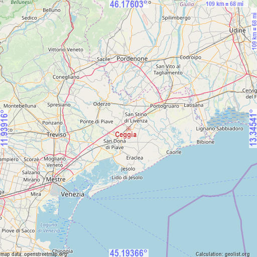
Ceggia GPS coordinates[2]
45° 41' 13.2" North, 12° 38' 32.208" East
| Map corner | latitude | longitude |
|---|---|---|
| Upper-left | 46.17603°, | 11.93916° |
| Center: | 45.687°, | 12.64228° |
| Lower-right: | 45.19366°, | 13.34541° |
| Map W x H: | 109.2×109.2 km | = 67.9×67.9mi |
| max Lat: | 47.04031° ⇑19.5% North |
| Ceggia: | 45.687° |
| min Lat: | ⇓80.5% South 35.50142° |
| min Long | Ceggia | max Long |
| 6.69888° | 12.64228° | 18.48682° |
| W 64.1%⇐ | ⇒35.9% E |
Elevation
Elevation of Ceggia is 2 m = 7 ft, and this is 304.7 m = 1000 ft below average elevation for this country.
| Max E: |
2085 m = 6841 ft | 99% |
| Avg. | 306.7 m = 1006 ft | |
| Ceggia | 2 m = 7 ft | |
Min E: |
-4 m = -13 ft | 1% |
See also: Italy elevation on elevation.city.
Geographical zone
Ceggia is located in North temperate zone (between Tropic of Cancer and the Arctic Circle). Distance of this North polar circle is 2321.3 km =1442.4 mi to North.| Distance of | km | miles | from Ceggia |
|---|---|---|---|
| North Pole | 4927.1 | 3061.6 | to North |
| Arctic Circle | 2321.3 | 1442.4 | to North |
| Tropic Cancer | 2474 | 1537.3 | to South |
| Equator | 5079.9 | 3156.5 | to South |


Nearby cities:
15 places around Ceggia: (largest is in red/bold)
• Calnova-Fiorentina
6.1 km =3.8 mi,  204°
204°
• Campo di Pietra
8.4 km =5.2 mi,  282°
282°
• Campobernardo
8.1 km =5 mi,  272°
272°
• Cessalto
3.7 km =2.3 mi,  322°
322°
• Chiarano
7.2 km =4.5 mi,  310°
310°
• Corbolone
7.3 km =4.5 mi,  16°
16°
• Fossalta Maggiore
9 km =5.6 mi, 305°
• Motta di Livenza
10.3 km =6.4 mi,  343°
343°
• Noventa di Piave
9 km =5.6 mi,  250°
250°
• Passarella
10.7 km =6.6 mi, 195°
• San Donà di Piave
8.6 km =5.3 mi,  222°
222°
• San Stino di Livenza
5.7 km =3.5 mi,  40°
40°
• Santa Maria di Campagna
3.8 km =2.4 mi,  296°
296°
• Stretti
6.7 km =4.2 mi,  147°
147°
• Torre di Mosto
4.5 km =2.8 mi,  91°
91°
Sources, notices
• [Note1] Compared only with cities in Italy existing in our database
• [Src1] Map data: © OpenStreetMap contributors (CC-BY-SA)
• [Src2] Other city data from geonames.org with taken over terms of usage.
• [Src3] Geographical zone / Annual Mean Temperature by Robert A. Rohde @ Wikipedia
