Castel Sant'Angelo geodata
Castel Sant'Angelo (Latium) is a seat of a third-order administrative division; located in Italy in Europe/Rome (GMT+2) time zone. With population of 480 people, there are 9990 cities with bigger population in this country. Compared to other cities in Italy, 66.9% of cities are located further ↑North; 68.6% of cities are located further ←West and 74.3% of cities have lower elevation than Castel Sant'Angelo. Note1


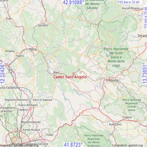
Castel Sant'Angelo GPS coordinates[2]
42° 23' 37.428" North, 13° 1' 38.568" East
| Map corner | latitude | longitude |
|---|---|---|
| Upper-left | 42.91086°, | 12.32426° |
| Center: | 42.39373°, | 13.02738° |
| Lower-right: | 41.8723°, | 13.73051° |
| Map W x H: | 115.5×115.5 km | = 71.8×71.8mi |
| max Lat: | 47.04031° ⇑66.9% North |
| Castel Sant'Angelo: | 42.39373° |
| min Lat: | ⇓33.1% South 35.50142° |
| min Long | Castel Sant'Ang | max Long |
| 6.69888° | 13.02738° | 18.48682° |
| W 68.6%⇐ | ⇒31.4% E |
Elevation
Elevation of Castel Sant'Angelo is 443 m = 1453 ft, and this is 136.3 m = 447 ft above average elevation for this country.
| Max E: |
2085 m = 6841 ft | 25.7% |
| Castel Sant'Angelo | 443 m 1453 ft | |
| Avg. | 306.7 m = 1006 ft | |
Min E: |
-4 m = -13 ft | 74.3% |
See also: Italy elevation on elevation.city.
Geographical zone
Castel Sant'Angelo is located in North temperate zone (between Tropic of Cancer and the Arctic Circle). Distance of this Northern Tropic circle is 2107.8 km =1309.7 mi to South.| Distance of | km | miles | from Castel Sant'Angelo |
|---|---|---|---|
| North Pole | 5293.3 | 3289.1 | to North |
| Arctic Circle | 2687.4 | 1669.9 | to North |
| Tropic Cancer | 2107.8 | 1309.7 | to South |
| Equator | 4713.7 | 2929 | to South |


Nearby cities:
15 places around Castel Sant'Angelo: (largest is in red/bold)
• Antrodoco
4.7 km =2.9 mi,  59°
59°
• Belmonte in Sabina
14.2 km =8.8 mi,  231°
231°
• Borbona
15.5 km =9.6 mi,  33°
33°
• Borgo Velino
2.7 km =1.7 mi, 62°
• Cantalice
12.8 km =8 mi,  308°
308°
• Casette
9.9 km =6.2 mi,  262°
262°
• Cittaducale
6 km =3.7 mi, 262°
• Concerviano
8.7 km =5.4 mi,  203°
203°
• Grotti
7.7 km =4.8 mi,  236°
236°
• Longone Sabino
14.4 km =8.9 mi, 200°
• Micigliano
6.8 km =4.2 mi,  18°
18°
• Petrella Salto
11.6 km =7.2 mi,  163°
163°
• Rieti
14 km =8.7 mi,  275°
275°
• Santa Croce
12.3 km =7.6 mi, 311°
• Santa Rufina
9.1 km =5.7 mi, 280°
Sources, notices
• [Note1] Compared only with cities in Italy existing in our database
• [Src1] Map data: © OpenStreetMap contributors (CC-BY-SA)
• [Src2] Other city data from geonames.org with taken over terms of usage.
• [Src3] Geographical zone / Annual Mean Temperature by Robert A. Rohde @ Wikipedia
