Santa Croce geodata
Santa Croce (Latium) is a populated place; located in Italy in Europe/Rome (GMT+2) time zone. With population of 562 people, there are 9332 cities with bigger population in this country. Compared to other cities in Italy, 66.4% of cities are located further ↑North; 67.3% of cities are located further ←West and 90.1% of cities have lower elevation than Santa Croce. Note1


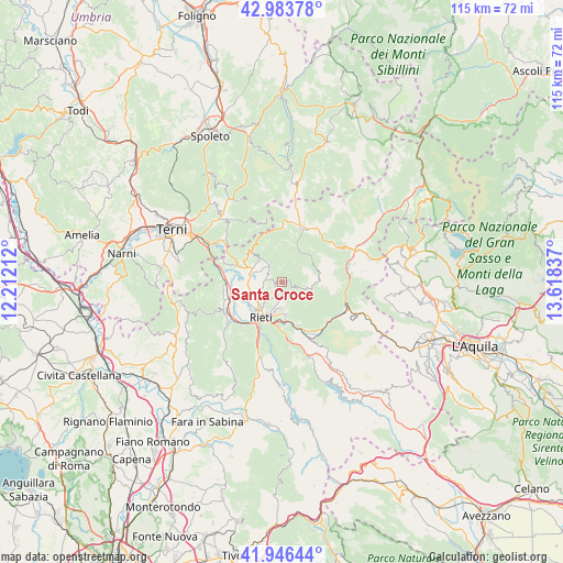
Santa Croce GPS coordinates[2]
42° 28' 2.136" North, 12° 54' 54.864" East
| Map corner | latitude | longitude |
|---|---|---|
| Upper-left | 42.98378°, | 12.21212° |
| Center: | 42.46726°, | 12.91524° |
| Lower-right: | 41.94644°, | 13.61837° |
| Map W x H: | 115.3×115.3 km | = 71.6×71.6mi |
| max Lat: | 47.04031° ⇑66.4% North |
| Santa Croce: | 42.46726° |
| min Lat: | ⇓33.6% South 35.50142° |
| min Long | Santa Croce | max Long |
| 6.69888° | 12.91524° | 18.48682° |
| W 67.3%⇐ | ⇒32.7% E |
Elevation
Elevation of Santa Croce is 724 m = 2375 ft, and this is 417.3 m = 1369 ft above average elevation for this country.
| Max E: |
2085 m = 6841 ft | 9.9% |
| Santa Croce | 724 m 2375 ft | |
| Avg. | 306.7 m = 1006 ft | |
Min E: |
-4 m = -13 ft | 90.1% |
See also: Italy elevation on elevation.city.
Geographical zone
Santa Croce is located in North temperate zone (between Tropic of Cancer and the Arctic Circle). Distance of this Northern Tropic circle is 2116 km =1314.8 mi to South.| Distance of | km | miles | from Santa Croce |
|---|---|---|---|
| North Pole | 5285.1 | 3284 | to North |
| Arctic Circle | 2679.3 | 1664.8 | to North |
| Tropic Cancer | 2116 | 1314.8 | to South |
| Equator | 4721.9 | 2934.1 | to South |


Nearby cities:
15 places around Santa Croce: (largest is in red/bold)
• Borgo San Pietro
4.1 km =2.5 mi,  318°
318°
• Cantalice
0.9 km =0.6 mi,  251°
251°
• Casette
9.4 km =5.8 mi,  183°
183°
• Castel Sant'Angelo
12.3 km =7.6 mi,  131°
131°
• Cittaducale
9.5 km =5.9 mi,  160°
160°
• Colli sul Velino
11.5 km =7.1 mi,  287°
287°
• Labro
11.4 km =7.1 mi,  304°
304°
• Leonessa
11.8 km =7.3 mi,  18°
18°
• Limiti di Greccio
12.1 km =7.5 mi,  262°
262°
• Micigliano
11.4 km =7.1 mi,  98°
98°
• Morro Reatino
9 km =5.6 mi,  312°
312°
• Poggio Bustone
4.7 km =2.9 mi,  328°
328°
• Rieti
8.4 km =5.2 mi,  214°
214°
• Rivodutri
7.3 km =4.5 mi, 318°
• Santa Rufina
6.5 km =4 mi, 177°
Sources, notices
• [Note1] Compared only with cities in Italy existing in our database
• [Src1] Map data: © OpenStreetMap contributors (CC-BY-SA)
• [Src2] Other city data from geonames.org with taken over terms of usage.
• [Src3] Geographical zone / Annual Mean Temperature by Robert A. Rohde @ Wikipedia
