Castagnaro geodata
Castagnaro (Veneto) is a seat of a third-order administrative division; located in Italy in Europe/Rome (GMT+2) time zone. With population of 2,764 people, there are 3249 cities with bigger population in this country. Compared to other cities in Italy, 62.9% of cities are located further ↓South; 51.8% of cities are located further →East and 93.6% of cities have higher elevation than Castagnaro. Note1


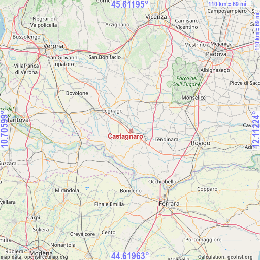
Castagnaro GPS coordinates[2]
45° 7' 4.62" North, 11° 24' 32.796" East
| Map corner | latitude | longitude |
|---|---|---|
| Upper-left | 45.61195°, | 10.70599° |
| Center: | 45.11795°, | 11.40911° |
| Lower-right: | 44.61963°, | 12.11224° |
| Map W x H: | 110.3×110.3 km | = 68.5×68.5mi |
| max Lat: | 47.04031° ⇑37.1% North |
| Castagnaro: | 45.11795° |
| min Lat: | ⇓62.9% South 35.50142° |
| min Long | Castagnaro | max Long |
| 6.69888° | 11.40911° | 18.48682° |
| W 48.2%⇐ | ⇒51.8% E |
Elevation
Elevation of Castagnaro is 11 m = 36 ft, and this is 295.7 m = 970 ft below average elevation for this country.
| Max E: |
2085 m = 6841 ft | 93.6% |
| Avg. | 306.7 m = 1006 ft | |
| Castagnaro | 11 m = 36 ft | |
Min E: |
-4 m = -13 ft | 6.4% |
See also: Italy elevation on elevation.city.
Geographical zone
Castagnaro is located in North temperate zone (between Tropic of Cancer and the Arctic Circle). Distance of this North polar circle is 2384.5 km =1481.7 mi to North.| Distance of | km | miles | from Castagnaro |
|---|---|---|---|
| North Pole | 4990.4 | 3100.9 | to North |
| Arctic Circle | 2384.5 | 1481.7 | to North |
| Tropic Cancer | 2410.7 | 1497.9 | to South |
| Equator | 5016.6 | 3117.2 | to South |


Nearby cities:
15 places around Castagnaro: (largest is in red/bold)
• Badia Polesine
7.2 km =4.5 mi,  110°
110°
• Baruchella
6.7 km =4.2 mi,  149°
149°
• Carpi
2.3 km =1.4 mi,  330°
330°
• Casale di Scodosia
9.7 km =6 mi,  31°
31°
• Castelbaldo
3.6 km =2.2 mi,  82°
82°
• Giacciano con Baruchella
6.5 km =4 mi, 150°
• Masi
6.4 km =4 mi,  99°
99°
• Menà
3.8 km =2.4 mi, 149°
• Merlara
6.1 km =3.8 mi, 27°
• Piacenza d'Adige
10.6 km =6.6 mi, 84°
• Spinimbecco
4.1 km =2.5 mi,  314°
314°
• Terrazzo
6.2 km =3.9 mi,  349°
349°
• Urbana
8.8 km =5.5 mi,  18°
18°
• Villa Bartolomea
6 km =3.7 mi, 313°
• Villa d'Adige
2.3 km =1.4 mi, 114°
Sources, notices
• [Note1] Compared only with cities in Italy existing in our database
• [Src1] Map data: © OpenStreetMap contributors (CC-BY-SA)
• [Src2] Other city data from geonames.org with taken over terms of usage.
• [Src3] Geographical zone / Annual Mean Temperature by Robert A. Rohde @ Wikipedia
