Merlara geodata
Merlara (Veneto) is a seat of a third-order administrative division; located in Italy in Europe/Rome (GMT+2) time zone. With population of 1,842 people, there are 4422 cities with bigger population in this country. Compared to other cities in Italy, 64.2% of cities are located further ↓South; 51.3% of cities are located further →East and 95.3% of cities have higher elevation than Merlara. Note1


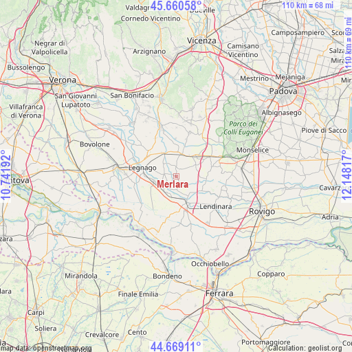
Merlara GPS coordinates[2]
45° 10' 1.2" North, 11° 26' 42.144" East
| Map corner | latitude | longitude |
|---|---|---|
| Upper-left | 45.66058°, | 10.74192° |
| Center: | 45.167°, | 11.44504° |
| Lower-right: | 44.66911°, | 12.14817° |
| Map W x H: | 110.2×110.2 km | = 68.5×68.5mi |
| max Lat: | 47.04031° ⇑35.8% North |
| Merlara: | 45.167° |
| min Lat: | ⇓64.2% South 35.50142° |
| min Long | Merlara | max Long |
| 6.69888° | 11.44504° | 18.48682° |
| W 48.7%⇐ | ⇒51.3% E |
Elevation
Elevation of Merlara is 8 m = 26 ft, and this is 298.7 m = 980 ft below average elevation for this country.
| Max E: |
2085 m = 6841 ft | 95.3% |
| Avg. | 306.7 m = 1006 ft | |
| Merlara | 8 m = 26 ft | |
Min E: |
-4 m = -13 ft | 4.7% |
See also: Italy elevation on elevation.city.
Geographical zone
Merlara is located in North temperate zone (between Tropic of Cancer and the Arctic Circle). Distance of this North polar circle is 2379.1 km =1478.3 mi to North.| Distance of | km | miles | from Merlara |
|---|---|---|---|
| North Pole | 4985 | 3097.5 | to North |
| Arctic Circle | 2379.1 | 1478.3 | to North |
| Tropic Cancer | 2416.2 | 1501.4 | to South |
| Equator | 5022.1 | 3120.6 | to South |


Nearby cities:
15 places around Merlara: (largest is in red/bold)
• Bevilacqua
8.3 km =5.2 mi,  331°
331°
• Carpi
5.3 km =3.3 mi,  228°
228°
• Casale di Scodosia
3.6 km =2.2 mi,  39°
39°
• Castagnaro
6.1 km =3.8 mi,  207°
207°
• Castelbaldo
5 km =3.1 mi,  170°
170°
• Masi
7.3 km =4.5 mi,  151°
151°
• Megliadino San Fidenzio
7.9 km =4.9 mi, 44°
• Megliadino San Vitale
7 km =4.3 mi,  62°
62°
• Montagnana
7.4 km =4.6 mi,  12°
12°
• San Fidenzio
7.9 km =4.9 mi,  46°
46°
• Spinimbecco
6.3 km =3.9 mi,  245°
245°
• Terrazzo
4 km =2.5 mi,  278°
278°
• Urbana
2.9 km =1.8 mi,  359°
359°
• Villa Bartolomea
7.3 km =4.5 mi,  259°
259°
• Villa d'Adige
6.5 km =4 mi,  186°
186°
Sources, notices
• [Note1] Compared only with cities in Italy existing in our database
• [Src1] Map data: © OpenStreetMap contributors (CC-BY-SA)
• [Src2] Other city data from geonames.org with taken over terms of usage.
• [Src3] Geographical zone / Annual Mean Temperature by Robert A. Rohde @ Wikipedia
