Casalpusterlengo geodata
Casalpusterlengo (Lombardy) is a seat of a third-order administrative division; located in Italy in Europe/Rome (GMT+2) time zone. With population of 12,674 people, there are 728 cities with bigger population in this country. Compared to other cities in Italy, 64.5% of cities are located further ↓South; 71.4% of cities are located further →East and 77% of cities have higher elevation than Casalpusterlengo. Note1


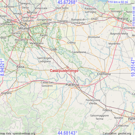
Casalpusterlengo GPS coordinates[2]
45° 10' 45.156" North, 9° 38' 54.024" East
| Map corner | latitude | longitude |
|---|---|---|
| Upper-left | 45.67268°, | 8.94521° |
| Center: | 45.17921°, | 9.64834° |
| Lower-right: | 44.68143°, | 10.35147° |
| Map W x H: | 110.2×110.2 km | = 68.5×68.5mi |
| max Lat: | 47.04031° ⇑35.5% North |
| Casalpusterlengo: | 45.17921° |
| min Lat: | ⇓64.5% South 35.50142° |
| min Long | Casalpusterleng | max Long |
| 6.69888° | 9.64834° | 18.48682° |
| W 28.6%⇐ | ⇒71.4% E |
Elevation
Elevation of Casalpusterlengo is 64 m = 210 ft, and this is 242.7 m = 796 ft below average elevation for this country.
| Max E: |
2085 m = 6841 ft | 77% |
| Avg. | 306.7 m = 1006 ft | |
| Casalpusterlengo | 64 m = 210 ft | |
Min E: |
-4 m = -13 ft | 23% |
See also: Italy elevation on elevation.city.
Geographical zone
Casalpusterlengo is located in North temperate zone (between Tropic of Cancer and the Arctic Circle). Distance of this North polar circle is 2377.7 km =1477.4 mi to North.| Distance of | km | miles | from Casalpusterlengo |
|---|---|---|---|
| North Pole | 4983.6 | 3096.7 | to North |
| Arctic Circle | 2377.7 | 1477.4 | to North |
| Tropic Cancer | 2417.5 | 1502.2 | to South |
| Equator | 5023.5 | 3121.5 | to South |


Nearby cities:
15 places around Casalpusterlengo: (largest is in red/bold)
• Bertonico
6.2 km =3.9 mi,  14°
14°
• Brembio
7 km =4.3 mi,  301°
301°
• Camairago
6.8 km =4.2 mi,  64°
64°
• Castiglione d'Adda
5.5 km =3.4 mi,  39°
39°
• Codogno
4.6 km =2.9 mi,  114°
114°
• Fombio
4.9 km =3 mi,  149°
149°
• Fornaci
3.2 km =2 mi,  46°
46°
• Mirabello
4.2 km =2.6 mi,  219°
219°
• Ospedaletto Lodigiano
5.6 km =3.5 mi,  258°
258°
• Retegno
5.1 km =3.2 mi,  130°
130°
• San Martino Pizzolano
2.7 km =1.7 mi,  230°
230°
• Senna Lodigiana
5.4 km =3.4 mi, 233°
• Somaglia
3.5 km =2.2 mi,  199°
199°
• Terranova dei Passerini
4.1 km =2.5 mi, 14°
• Zorlesco
3.5 km =2.2 mi,  312°
312°
Sources, notices
• [Note1] Compared only with cities in Italy existing in our database
• [Src1] Map data: © OpenStreetMap contributors (CC-BY-SA)
• [Src2] Other city data from geonames.org with taken over terms of usage.
• [Src3] Geographical zone / Annual Mean Temperature by Robert A. Rohde @ Wikipedia
